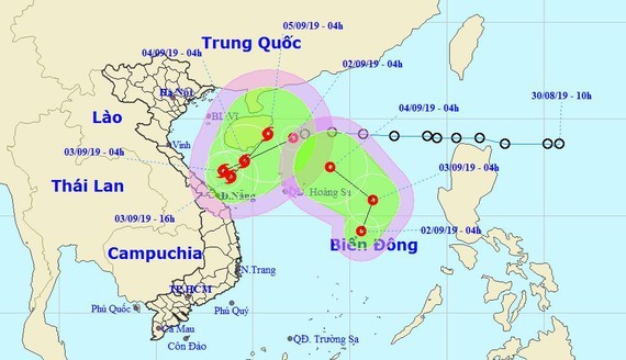
At 4am Monday, the eye of the tropical depression near the shore was swirled at around 220 kilometers from the Paracel Islands with its strongest winds of 40-60 kilometers an hour.
In the next 24 hours, the system is expected to move west- southwestward at a maximum speed of 15-20 kilometers per hour, and is able to develop into new storm.
By 4am tomorrow, the predicted storm will be centered at around 150 kilometers from Quang Tri to Quang Ngai mainland provinces. This dangerous zone will continue moving west- southwestward, and then turning northeastward within the next 24- 48 hours.
On the following days, the tropical typhoon is forecast at the mainland provinces.
Due to the tropical depression influence, violent winds of level 6-10, 3-4 meter big waves and rough sea begin to appear in the Gulf of Tonkin and territorial waters from Quang Tri to Binh Dinh from this afternoon.
In the early morning of September 2, the National Hydrology Meteorology Forecast Center provided visible images of the second tropical depression in the East Sea. As forecast, the second tropical depression will move slowly north- northeastward at a maximum speed of 5-10 kilometers an hour in the next 24 hours.
By 4am tomorrow, its eye is going to be at around 430 kilometers from the Paracel Islands with powerful winds of 40- 50 kilometers per hour near the center.
In the next 24- 48 hours, the system will move west- northwestward and be located at 220 kilometers from the Paracel Islands.


