Guarding against complacency in Nghe An
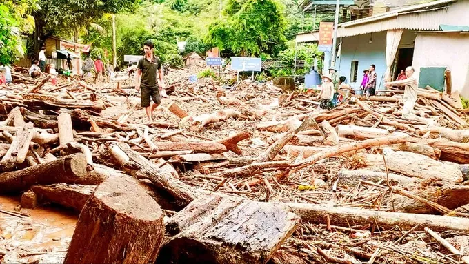
In the evening of July 23, Deputy Prime Minister Mai Van Chinh, leading a central government delegation, was on the ground in the flood-stricken Con Cuong Commune. His visit was aimed at inspecting the situation firsthand, offering encouragement to the affected residents, and directing the ongoing response and recovery operations.
According to Secretary Nguyen Duc Trung of the Nghe An Province Party Committee, a total of 16 communes across the province are situated within the flood zone. “Our military, police, and border guard units stationed in these areas are making every effort to help residents withstand the disaster and overcome its consequences”, he stated.
The province has also established numerous checkpoints and warning stations to prevent people from entering hazardous areas.
Deputy Prime Minister Mai Van Chinh acknowledged and praised the proactive and timely response of Con Cuong Commune and Nghe An Province at large. However, he also stressed the need for continued vigilance.
He urged provincial authorities and agencies to remain closely attuned to the “erratic and extreme” nature of the evolving flood situation. “We must pay close attention to our people”, he cautioned, “because once the rain stops, it’s easy to slip into a state of complacency, which can lead to further losses.”
The Deputy Prime Minister called on Nghe An to mobilize all available forces under the “four-on-the-spot” motto – on-site command, local forces, on-site resources, and local logistics – to participate in the recovery.
He repeated a firm directive from the Party Central Committee’s Secretariat that there is no room for complacency. All plans to ensure the safety of life and property for both the people and the State must be implemented with the utmost urgency.


Forecast: Heavy rains to persist in Northern and North-Central regions until July 25
While the sun broke through in Hanoi this morning, July 24, meteorological agencies are forecasting continued heavy rain for the North, even as the Central region experiences a heatwave. “Beginning on July 26, the heavy rainfall is expected to gradually diminish”, according to the National Center for Hydro-Meteorological Forecasting.
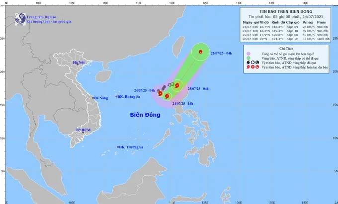
The Center reported that as of 4:00 a.m. today, the eye of Storm No.4 (Comay) was located at 16.7°N latitude and 118.3°E longitude, over the eastern part of the North of the East Sea. The storm is packing winds of level 8-9, with gusts up to level 11, and is currently moving south-southeast at approximately 15 km/h.
The storm is expected to alter its course, first turning east-southeast before gradually veering northeast. This afternoon, it is projected to strengthen to level 9-10, with gusts reaching level 12. By the morning of July 25, Comay is likely to pass north of Luzon Island in the Philippines, weakening slightly to level 8 intensity.
It is then forecast to continue northeast, losing strength and downgrading to a low-pressure system off the eastern coast of Taiwan by July 26. As such, the storm appears to be veering away and is not expected to make landfall in Vietnam.
Despite the storm’s new route, forecasters warn that weather conditions across the North and North-Central regions will likely worsen today with sudden thunderstorms. The primary cause, it appears, isn’t Storm No.4, but rather the combined effect of a highly active intertropical convergence zone and the southwest monsoon.
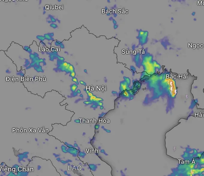
Overnight and into this morning, showers and thunderstorms were already recorded in the North, with some locations receiving over 100mm of rain, including Lao Cai (140.6mm) and Phu Tho (128.8mm).
From today through the night of July 25, the North, along with Thanh Hoa and Nghe An provinces, can expect continued moderate to heavy rain, with some areas facing torrential downpours. Total rainfall is forecast to range from 60-130mm, with some isolated spots potentially exceeding 250mm.
In contrast, hot and sunny weather will dominate the Central region, from Quang Tri Province to Hue City and along the South-Central coast, with temperatures climbing to 35-36°C.
The Central Highlands and the South will see afternoon and evening showers and thunderstorms, with localized heavy rain exceeding 80mm, bringing with it the risk of tornadoes, lightning, strong winds, and urban flooding.


