Previously, on July 21, the waters of Quang Ninh Province and Hai Phong City felt torrential rain and storm-force winds when the storm was located in the Gulf of Tonkin.
In the early hours of July 22, the eye of Storm No. 3 neared the mainland of Northern Vietnam, bringing heavy rain and strong winds to multiple areas.

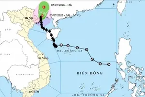
As updated by the National Center for Hydro-Meteorological Forecasting, as of 4 a.m. on July 22, the storm's center was located at approximately 20.5 degrees North latitude and 107.2 degrees East longitude, about 140 kilometers from Quang Ninh, 70 kilometers from Hai Phong, 80 kilometers from Hung Yen and 100 kilometers from Ninh Binh.

The storm had wind speeds of level 9–10 (88-102 kilometers per hour) with gusts reaching level 13 (134-149 kilometers per hour); and continued moving west-southwest at a speed of 15 kilometers per hour.

A representative from the Meteorological and Hydrological Administration stated that meteorological stations and the National Center for Hydro-Meteorological Forecasting are closely monitoring and continuously updating the hour-by-hour developments of the typhoon.
From the night of July 21 to the morning of the following day, the Red River Delta region and northern coastal areas, including Thanh Hoa and Nghe An provinces, experienced moderate to torrential rainfall, ranging from 50mm to 100mm, with some places exceeding 130mm.
It is forecast that through the end of July 23, these localities will continue to experience heavy rainfall, with amounts ranging from 200mm to over 500mm.
At 4:30 a.m.on July 22, weather radar images showed that the heaviest rainfall concentrated from Ninh Binh to Nghe An. Although the storm's eye has not yet made landfall, it has already approached the coastal area from southern Quang Ninh to Ninh Binh. It is expected to have widespread impact across the Northern and North-Central regions from morning to noon of July 22.
The storm’s impact varies by region. Meteorologists said that the storm center shifted south, bringing heavy rain and strong winds to its southern edge.

Nghe An, Hung Yen and Ninh Binh provinces were battered by rain and strong winds overnight while Hai Phong and several areas near the storm’s center remained unusually calm, making residents concerned.
Since the nighttime of July 21, the Gulf of Tonkin and the special zones of Co To and Bach Long Vi witnessed storm-force winds.
")
Both Vietnam’s National Center for Hydro-Meteorological Forecasting and international weather agencies predicted that around midday on July 22, the storm’s center would make landfall in Vietnam, with the strongest fury hitting the Northern coastal areas.
Coastal provinces in the North and North Central regions, especially Quang Ninh, Hai Phong, Hung Yen, Ninh Binh and Thanh Hoa are forecast to be located within the storm’s center and its circulation.
")
Heavy rain is expected to continue through July 23. The Northeast, Red River Delta and the provinces of Thanh Hoa and Nghe An may experience heavy rainfalls between 200mm and 350mm, with some areas exceeding 600mm.
Meanwhile, other northern provinces and Ha Tinh may see rainfall over 300mm, increasing the risk of sudden flash floods at midnight.
The National Center for Hydro-Meteorological Forecasting warned that the typhoon would not only bring heavy rain upon landfall but also form a tropical convergence zone, causing prolonged rainfall in the following days.
Northern mountainous localities including Thanh Hoa and Nghe An provinces face high risks of flash floods and landslides, even after the storm ends. Landslides can happen even after the rain stops due to prolonged soil saturation, added the weather agency.
At noon on July 21, Deputy Prime Minister Tran Hong Ha conducted an on-site inspection for storm preparedness at Ngoc Hai fishing port in Do Son Ward, Hai Phong City.
As reported, all vessels in the area had been moved to safe shelters. A total of 1,335 tourists have been staying in hotels and guesthouses, including 55 foreign visitors.
The Hai Phong City People’s Committee reported that over 6,600 households with more than 19,700 people living in areas at risk of landslides must be monitored and moved to safety areas as the storm approaches.
Deputy Prime Minister Tran Hong Ha urged the city to race against time and urgently evacuate residents from high-risk areas, especially coastal zones, landslide-prone regions, weak houses and old apartment buildings.