In an official dispatch issued on July 19, the Ministry of Agriculture and Environment called on People’s Committees of provinces and cities in the northern region and along the coast from Quang Ninh to Dak Lak to closely monitor Storm Wipha’s developments and be ready in response to it.
")
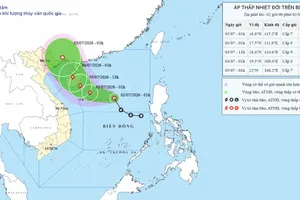
According to the dispatch, Storm Wipha entered the East Sea on the morning of July 19, intensifying into a level-9 storm with wind gusts reaching level 12. It is expected to strengthen further and unleash heavy rainfall across northern provinces in the coming days.
To minimise potential damage from flooding, flash floods, and landslides, local authorities have been instructed to strictly manage vessels at sea, and enforce safety protocols, and ensure the readiness of rescue forces and equipment.
In the Red River Delta and north-central coastal areas, officials are advised to inspect and prepare for the evacuation of residents living in unsafe housing or flood-prone zones, including river mouths and low-lying coastal areas. Measures should also be taken to secure sea and river dykes, and safeguard telecommunications and power networks to maintain uninterrupted services during and after the storm.
On the same day, the ministry’s Department of Dike Management and Disaster Prevention also issued a separate directive to agriculture-environment departments of 13 northern and north-central provinces, instructing them to prepare for storm-related risks to dike systems.
In an interview with the Vietnam News Agency, Mai Van Khiem, Director of the National Centre for Hydro-Meteorological Forecasting, said Storm Wipha is currently maintaining level 9 strength and could intensify to level 12 or 13. While the storm may weaken quickly as it moves over mainland China, it is forecast to maintain strength between levels 8 and 10 as it enters the Gulf of Tonkin.
The most immediate threat over the next 24 hours, Khiem warned, is strong winds and high waves in the northern and central East Sea, particularly around the Hoang Sa island.
From July 20-21, special zones such as Bach Long Vi, Co To, and Cat Hai are expected to experience high winds and heavy rainfall. By the early hours and throughout July 22, coastal waters from Quang Ninh to Thanh Hoa are likely to face direct impacts from winds of levels 7-9, heavy downpours, water surges, and waves as high as 3 to 5 meters.In combination with high tides, the large waves could inundate low-lying coastal areas in Quang Ninh and Hai Phong, particularly from midday on July 21 through to July 23.
On land, the storm’s impact zone is expected to span a wide area, affecting most of northeastern Vietnam, parts of the northwest, and north central provinces. Quang Ninh, Hai Phong, and coastal areas of Hung Yen, Ninh Binh, and Thanh Hoa provinces are forecast to be hardest hit by the storm’s full force.