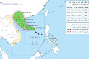
As updated by the National Center for Hydro-Meteorological Forecasting, as of 9 a.m. on July 20, storm Wipha (storm No.3) was located about 665 kilometers east of Mong Cai, the province of Quang Ninh.
The strongest wind near the center of the storm reached level 11-14 (103–166 kilometers per hour).
The storm was moving west-northwest at a maximum speed of around 25 kilometers per hour.
The northern waters of the East Sea is expected experience strong winds at levels 8–10 (74-102 kilometers per hour), while the areas near the eye of the storm will see wind levels 11- 15 (117-183 kilometers per hour), along with waves rising between 5 meters and 7 meters. The sea will be extremely rough.
Starting from the night of July 20, the northern waters of the Gulf of Tonkin, including the special zones of Bach Long Vi, Co To and Cat Hai will experience gradually strengthening winds.
Areas near the storm’s eye may see winds at levels 10–11 (102-117 kilometers per hour), gales of level 14 (150-166 kilometers per hour). Wave heights will range from 2 meters to 5 meters near the storm’s center, while the sea will be dangerously rough.
All maritime means operating in these hazardous areas may be affected by thunderstorms, whirlwinds and high waves.
On the afternoon of July 19, Mr. Hoang Phuc Lam, Deputy Director of the National Center for Hydro-Meteorological Forecasting, reported that storm No. 3 continued to intensify rapidly upon entering the East Sea.
Yesterday, Ha Long and Cam Pha, Quang Ninh Province saw hailstorms, severe thunderstorms and lightning. A lightning strike ignited vegetation on a rocky mountain in Ha Long Bay.
Heavy rain and strong winds have disrupted traffic on Bai Chay Bridge. Several cars had their windows shattered, and some homes suffered light damage.
In the provinces of Tuyen Quang, Thai Nguyen and Cao Bang, strong winds uprooted numerous trees and tore off metal roofing.
In several locations, vehicles were damaged by fallen trees and collapsed utility poles.
Meteorological experts stated that the violent windstorm over the capital city of Hanoi and the Northern provinces during the evening of July 19 was not a direct effect of storm No. 3, but rather due to the pre-storm atmospheric circulation.
Forecasts indicated that by the morning of July 22, the storm’s center could approach the mainland of Vietnam.
The meteorological agency forecasts that the storm will have a wide area of impact when it makes landfall.
Localities such as Quang Ninh, Hai Phong, Hung Yen, Ninh Binh and Thanh Hoa are expected to experience the most severe impacts in the days ahead.
On the same day, Prime Minister Pham Minh Chinh issued an official directive letter urging relevant ministries, agencies and local authorities to focus on responding to storm No. 3.
The Prime Minister requested the chairpersons of the People’s Committees of coastal provinces and cities from Quang Ninh to Quang Ngai to closely monitor the developments of the storm and to prepare personnel and equipment to carry out rescue and relief operations promptly when needed.