Authorities are urging residents to prepare food and essentials for at least three days and to evacuate from flood- and landslide-prone areas. Schools may close for safety.
The Da Nang City Military Command is on full alert from October 22 to October 30, and the local Border Guard has barred all vessels from going to sea.
At Tho Quang fishing port, over 3,500 local fishing boats and hundreds from other provinces have taken shelter. Fishermen in Son Tra are moving vessels ashore, while evacuation plans are underway in mountainous and border communes.
")
In Quang Ngai Province, more than 6,100 fishing boats with 34,300 fishermen have safely reached shelter. Signal flares at Sa Ky, Sa Can, Sa Huynh and Ly Son called vessels ashore. Ly Son authorities help residents reinforce homes, relocate floating fish farms, and mobilize residents to harvest 300 hectares of onions.
In Hue, local authorities are ready to evacuate more than 10,000 households, totaling 32,697 people, from coastal areas, lagoons and low-lying lands to safe locations. Nearly 100 tons of essential food and supplies have been stockpiled, and fuel companies are ensuring stable provision during prolonged rains and flooding.
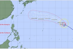
Updated by the National Center for Hydro-Meteorological Forecasting as of the evening of October 21, the center of storm No. 12 was over the northern waters of the Paracel archipelago, about 420 kilometers east-northeast of Da Nang. Maximum winds near the storm center remain at category 9–10 (equivalent to 75–102 kilometers per hour), with gusts reaching category 12.
Since the morning of October 21, the storm has shifted westward, then west-southwest, moving slowly at 10–15 kilometers per hour.
By the afternoon of October 22, the storm center is expected to be about 125 kilometers east-northeast of Da Nang, gradually weakening before making landfall in the Central region, primarily affecting the area from Da Nang to Quang Ngai.
From the afternoon of October 22 to October 23, storm No. 12 is expected to gradually weaken into a tropical depression, then into a low-pressure area, and dissipate as it moves into Laos.
Under the impact of the tropical storm, coastal areas from Quang Tri to Da Nang are forecast to experience sustained winds ranging from force 6–9 from the afternoon of October 22.
The storm’s circulation is likely to cause widespread heavy rain in localities from Ha Tinh to Quang Ngai between midday October 22 and October 27.

According to Mr. Mai Van Khiem, Director of the National Center for Hydro-Meteorological Forecasting, heavy rainfall in Central Vietnam could persist until the end of October 2025, posing a high risk of flash floods and landslides in mountainous areas, as well as flooding in low-lying and urban areas.
Local authorities are managing reservoirs, hydroelectric and irrigation systems to ensure safety before, during and after the storm, and are preparing response plans for floods on local rivers from Quang Tri to Quang Ngai, which may reach or exceed alert level 3, especially potential for thunderstorms and strong gusts within the storm’s circulation impact zone, both before and during landfall.
Northern region braces for cold spell
On the evening of October 21, cold air spread across most of the Northern region and parts of the North-Central region. The capital city of Hanoi experienced northeast winds, bringing a cool evening.
According to the National Center for Hydro-Meteorological Forecasting, a stronger cold air mass will move into the Northern region from October 22. Night and morning temperatures in Hanoi are expected to drop to 17–19 degrees Celsius, with some mountainous areas falling below 16 degrees Celsius.
Residents are recommended to keep warm during early mornings and evenings.