Based on the latest data, the storm’s center is forecast to move inland across the Da Nang–Quang Ngai area before weakening into a tropical depression. Earlier projections indicated the storm might downgrade to a tropical depression prior to landfall.
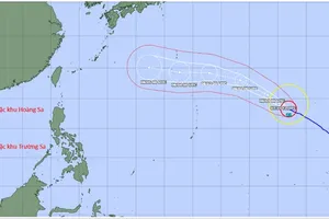
At 10 a.m. on October 21, the storm’s center was located near latitude 17.8 degrees North latitude and longitude 112.4 degrees East longitude, about 125 kilometers north of the Paracel Islands. Maximum sustained winds near the center remain at 75–102 kilometers per hour (equivalent to force 9–10), with gusts up to category 12. The storm is currently moving southwest at a maximum speed of 15 kilometers per hour.

The National Center for Hydro-Meteorological Forecasting reported that over the next 24 to 48 hours, the typhoon would continue moving southwest at 10–15 kilometers per hour, maintaining wind speeds at category 8 with gusts up to category 10.
From October 22 through the morning of October 23, the storm is expected to move southwestward across the areas between Da Nang and Quang Ngai, then will weaken into a tropical depression and a low-pressure area respectively.
Meteorologists continue to warn of the potential for very heavy and prolonged rainfall across the Central region through the end of October under impacts of the storm’s circulation interacted with a cold air mass, easterly winds and local terrain effects. Heavy, widespread rainfall is likely across areas from Ha Tinh to Quang Ngai from the night of October 22 through October 27.