Traveling by boat from Thu Dau Mot along the Saigon River as it flows past the Ben Nghe estuary to the sea at Can Gio, ascending Nui Lon in Vung Tau Ward to take in the sweeping arc of blue waters from Xuyen Moc to Ganh Rai Bay, or boarding a high-speed vessel from the Thu Ngu Flagpole in Saigon Ward bound for the distant Con Dao archipelago, residents and visitors can experience up close the scale of Vietnam’s largest river–sea metropolis, formed as Ho Chi Minh City integrates with Binh Duong and Ba Ria–Vung Tau.
Ho Chi Minh City turns to rivers and seas for future growth
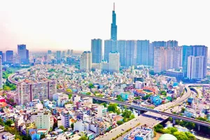
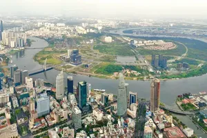
The sprawling metropolis of Ho Chi Minh City is home to a vast network of over 1,000 km of rivers and a 300 km coastline overlooking a massive 100,000 sq km continental shelf. Beyond the mainland lies the breathtaking Con Dao, an exquisite 'cluster of pearls' made up of more than 16 islands of all sizes. The city is also home to more than 90 seaports of varying scale, handling around 70 percent of the country’s containerized import-export cargo.
In addition, nearly 300 inland ports thrive along the Saigon River and surrounding canals, providing vital links to the Southeast and the Mekong Delta. With a population of 14 million, half a million businesses, 66 industrial zones, and a concentration of over 60 universities and premier research centers, the city possesses an immense wealth of human and structural capital. This rich resource ecosystem empowers the city to chart a prosperous future, driven by its rivers and the vast ocean.
Historically, riverine and coastal areas have been centers of livelihood through fishing and aquaculture. In Can Gio, alongside traditional fishing and salt-making, the late 20th century saw the emergence of bird’s nest farming and aquaculture operations. Vung Tau’s waters, long known for rich fishing grounds and tourism, saw the rise of oil and gas facilities in the 1980s. Two of the largest shipbuilding yards in the Southern region, Ba Son and CARIC, were established and developed in what was once Saigon.
Over more than 150 years, a chain of ports stretching from river to sea has been built, forming the backbone of the city’s maritime and trading strength. At its core are the Saigon Port system, Tan Cang, and Cai Mep–Thi Vai.
These economic activities reflect the efforts of many generations and now require renewed momentum to fully harness the advantages of a vast river–sea urban system. Over the past five years, before administrative consolidation, Ho Chi Minh City’s leadership made a strategic decision to “pivot development” toward its river and marine assets. Urban planners have not only focused on the Can Gio estuary but have also expanded their vision to include the Saigon River and its interconnected waterways.
Since 2024, a master plan for landscape and architectural development along the Saigon River through 2045 has been developed in collaboration with the Paris Region Planning Institute. Following the merger, city leaders have added several key directions tied to river–sea development, including stronger integration between ring roads, logistics infrastructure, and port systems; the development of green ports; expansion of interregional waterways; and coastal road projects. Notably, plans include a 54-kilometer metro line from Ben Thanh to Can Gio and the establishment of the Cai Mep Ha Free Trade Zone, covering 3,800 hectares.
These initiatives represent foundational steps toward shaping a new, integrated growth model known as the River–Ocean Economy. In the 21st century, this concept reflects a broader understanding of river and marine resources, particularly for a complex and multi-centered metropolis like Ho Chi Minh City. A modern River–Ocean Economy extends beyond traditional sectors such as fisheries, oil and gas extraction, maritime transport, and tourism. Like other advanced economic domains, it increasingly integrates diverse and specialized industries, driven by scientific and technological innovation.
Ho Chi Minh City eyes a river metropolis future
In developing a river–sea economy, not only Ho Chi Minh City but also other provinces must carefully assess and prioritize investment in sectors that offer the highest returns and strongest feasibility. This requires going beyond existing resources to account for shifts in global markets.
Recent developments illustrate the challenge. The conflict in the Middle East has driven up fuel prices, sending shockwaves through maritime transport costs. Alongside ongoing “tariff wars,” what might be termed a “black gold war” is placing significant strain on aviation, shipping, tourism, fisheries trade, and other sectors. As a result, strategies across transportation, trade, production, and consumption, particularly in the extraction, trading, and storage of energy, must be recalibrated.
In this context, countries must reposition and adjust strategies across river–sea-related industries, starting with oil and gas infrastructure, seaports, logistics systems, and industrial zones. More broadly, most sectors will require adaptive adjustments to strengthen economic resilience amid uncertainty while still meeting long-term development goals.
At the same time, studying the development and competitive strategies of river–sea economies in neighboring Southeast and East Asian countries is essential. Singapore, for instance, from the mid-20th century, focused on building oil refineries and container ports while simultaneously expanding finance, telecommunications, high technology, aviation, and tourism. Over the past three decades, it has persistently pursued land reclamation, desalination, and offshore farming. These experiences highlight the potential for integrating river–sea economic activities with a wide range of other industries.
Ho Chi Minh City holds significantly greater potential than Singapore and several regional urban centers in advancing a river–sea economy under new conditions. It benefits from an extensive network of rivers integrated with a long coastline, as well as major islands under relatively stable climatic conditions. More importantly, its maritime and aviation connectivity positions it as a gateway for Vietnam, southern Indochina, and ASEAN. Historically, the Saigon – Vung Tau – Con Dao axis has served as a strategic stopover along Europe–Asia–America trade routes.
As the city prepares to develop the full spectrum of modern river–sea economic sectors, it should leverage existing advantages to rapidly establish several key “spearhead” facilities serving both domestic and international demand. These include an offshore transshipment container port in Can Gio, a comprehensive marine logistics base in Con Dao, and an interconnected port and coastal corridor linking Dong Nai, Ho Chi Minh City, and Can Tho.
Complementing these are systems of seafood processing and marine pharmaceutical plants, as well as riverine and offshore farms and laboratories. The emerging International Financial Center in Ho Chi Minh City should also develop specialized services such as maritime and oil and gas insurance, port construction financing, and green energy credit.
In tourism, the city can promote more effective use of maritime and river routes, historic ports, and associated cultural heritage through “memory tourism” models. At the same time, it should capitalize on its human resources to advance river–sea economic development by establishing integrated education and research complexes in maritime studies, oceanography, fisheries, and related services at national and regional scales.
Alongside the existing university and high-tech zones in Thu Duc and Cu Chi, the city could develop additional “Sciences Town” and “University Town” clusters in Can Gio, Ba Ria, Vung Tau, and Con Dao, combining research with practical implementation across river–sea sectors and major projects.
In reality, Ho Chi Minh City is emerging as a hub for converging financial flows, with its river–sea advantage standing out as a strategic asset that must not be overlooked. With a clear vision and renewed momentum, the city is well positioned to become a prosperous “river metropolis,” echoing the legacy it has long been building.
Heritage economy promoted
More than 320 years ago, the land of Saigon originated from fishing villages along estuaries and inland waterways. In the 17th century, Vietnamese migrants arriving by sea joined local inhabitants to expand the land, establishing numerous villages and wharves. Saigon was interconnected with the upper region of Dong Nai and the lower region of Tien Giang through various river and sea routes. Thanks to its proximity to the ocean, the area possessed deep, wide waterways and a favorable climate.
Starting in the 18th century, during the era of burgeoning Euro-Asian trade, Saigon evolved rapidly from a small "transit town" into a pivotal port city and urban center in Southern Indochina. It grew on a scale far surpassing contemporary Hoi An in the Central region or Ke Cho (Hanoi) in the North. Upon seizing Saigon in 1859, the French leveraged its prime river-sea location to develop modern economic sectors. The Commercial Port of Saigon (1860) and the Ba Son Shipyard (1863) served as two pioneering industrial and service pillars. By adopting a "free port" policy (tax-free), the Port of Saigon competed effectively and fairly with Singapore and Hong Kong. Consequently, the name Saigon appeared on global maritime maps as an indispensable port of call on numerous international shipping routes.
From the 1880s, in addition to maritime, rail, and road networks, Saigon served as the inland waterway transport hub of Southern Indochina. Therefore, it can be said that within the form and internal strength of a city shaped over 320 years, the elements of canals, rivers, and the open sea have always been the integral components forming its great power and foundation.
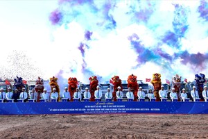
Following the merger on July 1, 2025, Ho Chi Minh City has integrated further economic, cultural, and historical resources from the former territories of Binh Duong and Ba Ria - Vung Tau. The Saigon River now links Thu Dau Mot with the city center, while Can Gio connects with Vung Tau and Xuyen Moc. A vast array of orchards, craft villages, towns, temples, wharves, and tourist sites stretching along the rivers, canals, and islands of the expanded city constitute an abundant "resource" for the cultural industries and the heritage economy, both now and in the future.