Localities including Hue, Da Nang, Quang Nam and Quang Ngai experienced persistent heavy rainfall from the night of June 11 through the morning of June 12, with total rainfall ranging from 100 mm to 200 mm, even exceeding 300 mm within just a few hours.
The National Center for Hydro-Meteorological Forecasting reported that at 4 a.m. on June 12, storm Wutip was centered at 16.7 degrees North latitude and 110.7 degrees East longitude, in the western part of the Paracel Islands.
")
The storm maintained a strength of level 8–9 (62–88 kilometers per hour), with wind gusts reaching level 11 (103–117 kilometers per hour). It moved west-northwest at an hourly speed of 10–15 kilometers.
It is forecast that within the next 24 hours, the storm will intensify to level 10 (89-102 kilometers per hour), with gusts up to level 13 (134-149 kilometers per hour), approaching the southern part of Hainan Island (China), then it will shift northward and gradually downgrade after June 14.
Due to the impact of the storm, on June 12 and June 13, the mid-Central region will continue to experience intense rainfall, ranging from 100 mm to 200mm, with some areas exceeding 350 mm.
In particular, Quang Nam, Da Nang and Hue may record rainfall of 400mm–500 mm, while Ha Tinh and the northern part of the Central Highlands will also suffer from moderate to heavy rainfall ranging from 30mm to over 150mm.
Meteorological experts recommended residents in affected areas to proactively take precautionary measures. Local people in low-lying areas should move their private vehicles and belongings to safe locations, limit travel during heavy rains, and absolutely avoid passing through deeply flooded or fast-flowing water areas.
Vessels and boats operating in the northern part of the East Sea and off the central coast should urgently return to shore and move away from dangerous areas.
According to the National Center for Hydro-Meteorological Forecasting, rainfall in the Central region is expected to gradually decrease from June 14 as the storm moves northward and weakens.
On the morning of June 12, torrential rains caused flooding and isolation in multiple low-lying areas in Quang Tri.


As reported by the Steering Committee for Natural Disaster Prevention and Search and Rescue in Quang Tri, moderate to heavy thunderstorms are forecast to hit the locality on June 12 and June 13.
Rainfall is expected to range from 80 mm to over 250 mm. Thunderstorms may also bring a risk of cyclones and strong gusty winds.
Chairman of the People's Committee of Dai Hung Commune, Dai Loc District, Quang Nam Province Nguyen Quoc Than indicated that storm-triggered heavy rainfall has resulted in the flooding of over 300 houses in the commune, along with isolated roads.

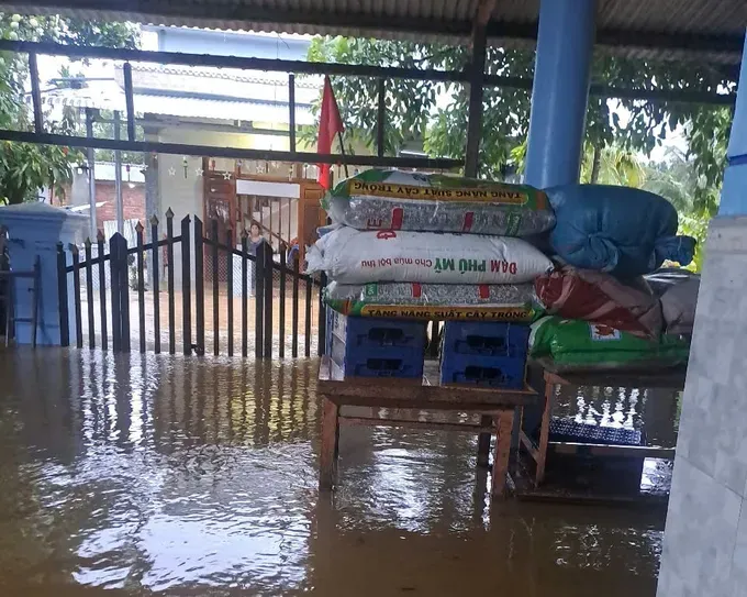
Additionally, more than 100 hectares of crops and over 220 hectares of summer-autumn rice, which had been sown for about 15 days, were submerged and completely damaged.

At the current time, the local authorities have already arranged forces on duty in vulnerable areas, posted warning signs and cordoned off dangerous zones to prevent people from passing through flooded roads.
On June 12, the Management Board of Son Tra Peninsula and Da Nang Tourist Beaches released reports on the landslide situation in Son Tra Peninsula caused by the storm.

According to the report, the circulation of storm No. 1, named Wutip, caused widespread heavy rainfall in Son Tra Peninsula from June 11 until June 12, leading to landslides in several areas, falling rocks and uprooted trees.

In response to the situation, the Management Board of Son Tra Peninsula and Da Nang Tourist Beaches has proactively suspended tours on the routes of Yet Kieu – Bai Bac, Bai Bac – Cay Da and Tien Sa –Om Stream– Ban Co Peak.
At the same time, they sent forces to clear up fallen branches, remove debris and rocks, and address landslide points along the routes.


