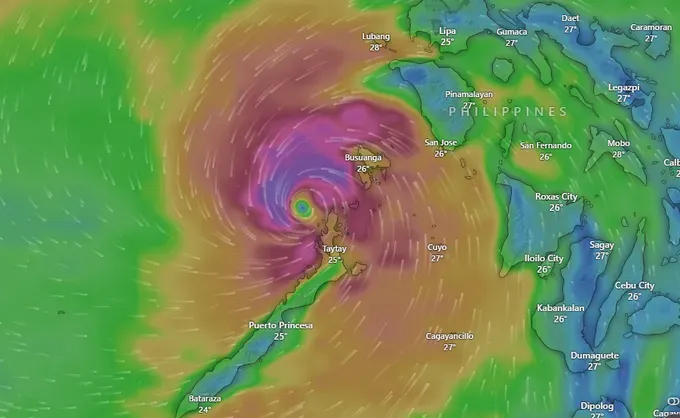
According to the National Center for Hydrometeorological Forecasting, at 4 a.m. on November 5, typhoon Kalmaegi’s center was located near 11.4 degrees north latitude and 119.4 degrees east longitude, about 560 kilometers east of Song Tu Tay (Southwest Cay) Island. Maximum sustained winds near the center reached 134–149 kilometers per hour (equivalent to category 4), with gusts up to 184-201 kilometers per hour (category 16).
Typhoon Kalmaegi is moving west-northwest at 20–25 kilometers per hour and is expected to strengthen further.
By 4 a.m. on November 6, the storm is projected to be near 12.8 degrees north latitude, 113.9 degrees east longitude, roughly 550 kilometers east-southeast of Gia Lai Province’s coast, with peak winds of 150-166 kilometers per hour (category 14), gusting to 202-220 kilometers per hour (category 17). Kalmaegi is expected to make landfall on November 7, over inland areas from Quang Ngai to Dak Lak provinces, with winds of 88-102 kilometers per hour (category 9–10), gusting to 118-133 kilometers per hour (category 12).
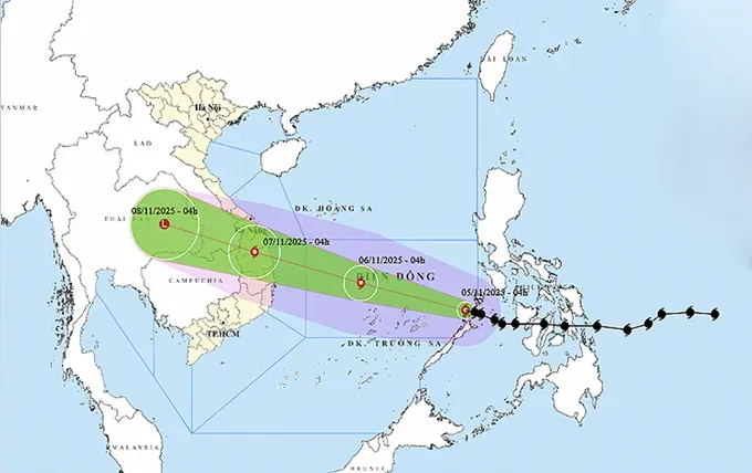
Across the East Sea, sustained winds of 88–117 kilometers per hour, increasing to 133-166 kilometers per hour near the storm’s core, will generate waves eight to nine meters high and extremely rough seas.
From early November 6, coastal waters from Da Nang to Khanh Hoa provinces and Ly Son Special Zone, will experience wind forces of 88–117 kilometers per hour, gusting to category 17, with storm surge heights of 0.3–0.6 meters and waves of six to eight meters.
Beginning late November 6, coastal and inland areas from southern Quang Tri to Dak Lak provinces will see strong winds 74-88 kilometers per hour, increasing to 102-133 kilometers per hour near the storm center, with gusts up to 166- 183 kilometers per hour. Torrential rainfall is forecast for November 6 and November 7.
Rainfall from Da Nang to Dak Lak is expected to range from 200 to 400 millimeters, with some areas topping 600 millimeters. From southern Quang Tri to Hue, Khanh Hoa and Lam Dong, totals of 150 to 300 millimeters are likely, with isolated spots exceeding 450 millimeters. Rainfall is forecast to taper off beginning November 8.
The National Hydrometeorological Forecasting Center warns that typhoon Kalmaegi’s wide circulation could trigger thunderstorms, whirlwinds and intense gusts before and during landfall.
Therefore, local authorities from Quang Tri to Dak Lak provinces are urged to evacuate residents from coastal and low-lying areas and prepare for flooding, landslides, flash floods and marine hazards.






)


