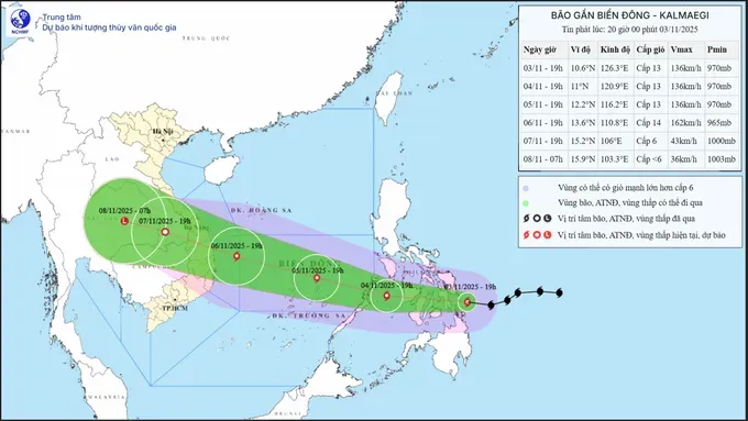
Winds could reach level 13 (134–149 km per hour) to level 14 (150–166 km/h), with gusts up to level 15 (167–183 km per hour), while over the sea and maintain level 10 (89–102 km per hour) to level 12 (118–133 km per hour), with gusts of level 14 to 15, as it moves inland along the coast.
On the evening of November 3, the Office of the National Center for Hydrometeorological Forecasting under the Ministry of Agriculture and Environment had issued an official dispatch to the Office of the National Civil Defense Steering Committee and the People’s Committees of the provinces and cities of Nghe An, Ha Tinh, Quang Tri, Thua Thien-Hue, Da Nang, Quang Ngai, Gia Lai, Dak Lak, Khanh Hoa, and Lam Dong, as well as to relevant ministries, regarding the situation of heavy rainfall, flooding, and typhoon Kalmaegi.
At present, water levels on rivers in the Central region remain high, and widespread flooding has been reported across multiple localities.

Regarding the heavy rainfall, the intensifying cold air mass, combined with several other factors, including the intertropical convergence zone, a low-pressure area over the southern East Sea, and upper-level easterly disturbances, has brought persistent downpours to the region.
From the afternoon of November 3 through the end of November 4, areas from Ha Tinh Province to Hue City are expected to experience heavy to extremely heavy rain, with total rainfall ranging from 150 to 250 millimeters, and localized areas possibly exceeding 400 millimeters. Rainfall in these regions is likely to decrease between November 5 and 6.
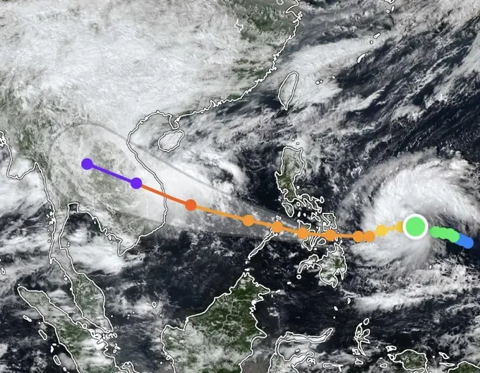
Regarding typhoon Kalmaegi, forecasts indicate that by the morning of November 5, the storm will enter the East Sea and become the country’s 13th tropical storm of 2025.
Although observational data as of November 3 still carry a degree of uncertainty regarding the storm’s track and intensity, the latest projections suggest that Kalmaegi is moving rapidly and possesses very strong intensity. The National Center for Hydrometeorological Forecasting will issue an emergency storm bulletin as soon as the typhoon enters the East Sea on the morning of November 5.

According to the Head of the National Center for Hydrometeorological Forecasting, typhoon Kalmaegi could reach level 13 to 14 in intensity while moving over the Truong Sa (Spratly) Archipelago and the waters between Da Nang and Khanh Hoa.
Starting from the night of November 6, the storm is expected to directly impact coastal areas from Da Nang to Khanh Hoa. Winds over nearshore waters, including the Ly Son Special Zone, may reach level 12 to 13, with gusts exceeding level 15. Along the coastal mainland, winds could reach level 10 (89–102 km per hour) to 12, with gusts of level 14 to 15.
This is anticipated to be a powerful storm, and thunderstorms and tornado-like whirlwinds may occur in the period ahead of the typhoon’s landfall.
The National Center for Hydrometeorological Forecasting has issued a warning that water levels on rivers across the Central region remain high, and widespread flooding is occurring in many localities.
The agency has urged provincial People’s Committees to direct reservoir management and operation units to closely monitor meteorological and hydrological developments, maintain observation and forecasting protocols, and promptly provide data, information, and reports in accordance with the Center’s regulations to support ongoing forecasting and early warning efforts.


)


