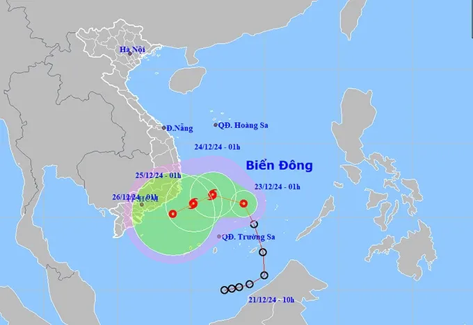
According to the forecast from the National Center for Hydro-Meteorological Forecasting, from the night of December 23 to December 24, several localities in the Central region from Da Nang to Khanh Hoa will experience moderate to heavy rains, even localized intense rainfall of over 200mm.
From the night of December 24 to December 25, the Central and South-Central regions, along with the eastern Central Highlands region, will continue to experience heavy rain.
The meteorological agency also reported that on the afternoon of December 22, the center of the tropical depression in the East Sea moved to approximately 7.6 degrees North latitude and 114.9 degrees East longitude, about 350 kilometers far from east-southeast of the Spratly Islands.
The strongest wind speed reached 50-61 kilometers per hour, gusts at 75-88 kilometers per hour, moving north at a hourly speed of at least 20 kilometers.
By the afternoon of December 23, the tropical depression is expected to move north-northwest at a speed of 15 to 20 kilometers per hour, potentially strengthening into a storm in the southwestern waters in the middle of the East Sea, with a strength of 62-102 kilometers per hour.
On December 24, the storm is forecast to move west at about 10 kilometers per hour in the southwestern waters in the middle of the East Sea, continuing to maintain its strength.
This is an unusual off-season storm with a complex development. The southern East Sea, including the Spratly Islands and the southwestern waters of the middle of the East Sea is the initially-affected area.


)


