According to the Japan Meteorological Agency, starting from the afternoon of July 13, the low-pressure system, developed along the tropical convergence zone, in the East Sea has strengthened into a tropical depression.
By the evening of July 13, Vietnam's National Center for Hydro-Meteorological Forecasting officially announced this tropical depression.
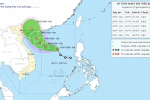
As of 1 a.m. on July 14, the center of the tropical depression was located around 13.6 degrees North latitude and 112.5 degrees East longitude, over the Western part of the Central East Sea. It has maximum winds of up to level 6 (39-49 km/h), gusting to level 8, moving northwestward at a speed of 5-10 km/h.
The forecast until the morning of July 15 predicts that the tropical depression will continue its northwestward movement at a speed of 10-15 km/h, with winds intensifying to level 6-7, gusting to level 9, towards the coastal areas from Quang Binh to Quang Ngai.
The tropical depression is currently and will directly affect the Western sea areas of the Central East Sea and the Southwestern sea areas of the Northern East Sea (including the Hoang Sa Archipelago).

From today, July 14, offshore waters from Quang Tri to Binh Dinh will experience strong winds up to levels 6-7, gusting to level 9, and rough seas. Wave forecasts for the Western waters of the central East Sea and Southwestern parts of the Northern East Sea (including the Hoang Sa Archipelago) indicate waves reaching heights of 2-4 meters. Starting July 14, offshore sea areas from Quang Tri to Binh Dinh will see waves ranging from 1.5 to 3 meters high.
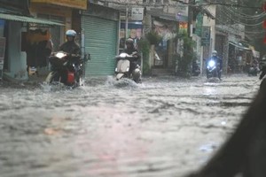
The National Center for Hydro-Meteorological Forecasting predicts heavy rainfall from tonight, July 14, to July 17 in the Red River Delta, coastal areas of the Northern region, Central Highlands, and Southern region. Rainfall amounts are expected to range from 60-120mm across these areas, with some places receiving over 200mm. The North Central and Central Coastal regions may experience widespread rainfall of 100-200mm, with localized rainfall exceeding 250mm.
Geological experts note that recent days have seen alternating heatwaves and heavy rains in many highland areas of the Northern and Central regions. Hillsides along national and provincial roads have suffered erosion, washing out, and deforestation, impacting geological stability and loosening soil cohesion after prolonged rainfall, thereby increasing the risk of landslides.
Therefore, at this time, residents and vehicles should avoid traveling through areas with dangerous terrain and landslide risks, particularly on routes prone to landslides.