")
However, the Japan Meteorological Agency has not yet confirmed this typhoon, so it currently remains unnamed.
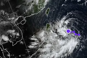
The Vietnam National Center for Hydro-Meteorological Forecasting (NCHMF) reported at 2 a.m. on July 21 that the tropical depression was located at approximately 16.3 degrees North latitude and 112.3 degrees East longitude, in the waters of the Hoang Sa Archipelago.

According to several meteorological experts not affiliated with the NCHMF, Typhoon No.2 was operating at level 8 (62-74km/h) this morning, July 21, and was moving westward but is expected to shift northwest today, with a high risk of penetrating deeply into the Gulf of Tonkin.
")
Previously, international meteorological centers and the NCHMF predicted that the typhoon's center would move into the Eastern area of Hainan Island, China. However, based on updated data this morning, meteorological experts believe that due to the tropical depression outside the East Sea intensifying into Typhoon Gaemi, it has strongly interacted with the typhoon in the East Sea, leading to a 90 percent probability that Typhoon No.2 will move into the Gulf of Tonkin.
Due to the typhoon's influence, the Gulf of Tonkin and the coastal areas of Quang Ninh, Hai Phong, and Thai Binh should be on alert for severe weather, as the typhoon could strengthen to level 9, with gusts up to level 11. On land, the entire Northeastern region is likely to experience rain over the next two days, with Quang Ninh and potentially Hai Phong being the focal points.

According to SGGP newspaper reporters, this morning, July 21, large thunderstorm clouds appeared in Hai Phong, potentially bringing heavy rain combined with rising sea levels and floodwaters from the Northern rivers, creating a high risk of flooding.
In the South, widespread rain, concentrated in the Southeastern region and the Central Highlands, prompted the NCHMF to issue a flood warning for the Dong Nai River as of early this morning, July 21.

At 1 a.m. this morning, the flood level at Ta Lai Station on the Dong Nai River was just 0.03m below alarm level 2. It is forecasted that today, the flood level on the Dong Nai River may exceed alarm level 2, causing flooding in Tan Phu and Dinh Quan districts of Dong Nai Province and some nearby areas.


)