The National Center for Hydro-Meteorological Forecasting reported that on the evening of October 22, the storm weakened to a tropical depression as it moved toward the Central Coast.
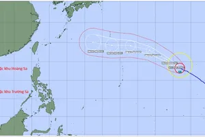
As of 1 a.m. on October 23, the center of the tropical depression was located over the waters from southern Quang Tri to Quang Ngai, about 80 kilometers east-northeast of Da Nang City. Maximum sustained winds near the center reached category 6 (equivalent to 39–49 kilometers per hour), with gusts up to category 8. The system is currently moving southwestward at 10–15 kilometers per hour.
The center forecasts that from the morning through the afternoon of October 23, the tropical depression will make landfall over the areas from Da Nang to Quang Ngai, then continue to weaken into a low-pressure area with winds below force 6.
According to the Joint Typhoon Warning Center (JTWC), as of 7 a.m. (Vietnam time), the tropical depression’s center was about 40–60 kilometers off the coast between Hue and Da Nang.
Due to the combined effects of the tropical depression and a cold air mass, the coastal waters from Quang Tri to Quang Ngai, including Con Co, Cu Lao Cham, and Ly Son islands are expected to experience strong winds at category 6, gusting to category 8.
 model, was updated at around 7 a.m. on October 23.")
Along the coast from southern Quang Tri to Da Nang, sea levels may rise 0.3–0.6 meters due to strong onshore winds. Residents in low-lying coastal areas should remain alert for high waves, tidal surges and flooding, which could inundate roads and cause coastal erosion.
All fishing boats, ships and aquaculture facilities in the affected area may experience thunderstorms, gusty winds, rough seas and rising water levels.
The meteorological center also warns of ongoing risks of heavy rainfall and flooding due to the storm’s circulation.
From October 23 through the night of October 24, heavy to very heavy rainfall is expected from Ha Tinh to Quang Ngai, with the heaviest rainfall ranging between 200 and 400 mm, locally over 700 mm forecast from southern Quang Tri to Da Nang.