By early morning on October 23, this system is expected to enter coastal waters from Hue to Quang Ngai, with its center near Da Nang City.
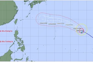
Following the latest updates from the National Center for Hydro-Meteorological Forecasting, as of 5 a.m. on October 22, the storm’s center was located at 17.1 degrees North latitude, 110.8 degrees East longitude, approximately 290 kilometers east-northeast of Da Nang. Maximum sustained winds near the center reach 89–102 kilometers per hour (equivalent to category 10) with gusts up to level 12.

The storm is moving west-southwest at around 10 kilometers per hour, with signs of slowing down in the next three hours. Forecasters expect it to gradually weaken into a tropical depression after making landfall.
According to the forecast model of the National Center for Hydro-Meteorological Forecasting, by the early morning of October 23, storm No. 12 is expected to be over the coastal area from Hue to Quang Ngai, with its center near Da Nang. The storm is forecast to gradually weaken into a tropical depression.
The National Center for Hydro-Meteorological Forecasting warns that the western waters of the northern East Sea, including the Paracel Islands, began experiencing strong winds of category 7–8. Near the storm center, winds reach category 9–10, gusts up to 12. The waters from Quang Tri to Quang Ngai, including Con Co, Cu Lao Cham and Ly Son islands, see winds of category 6–7, and level 8 near the storm center with gusts up to 10, and rough seas.
Storm surge is expected along the coast from Quang Tri to Da Nang.
All vessels in the area are at risk from gales, strong winds and huge waves. Low-lying coastal areas and river mouths from Quang Tri to Da Nang should prepare for flooding and possible coastal erosion. Heavy rainfall is expected during and after the storm.
According to Mr. Mai Van Khiem, Director of the National Center for Hydro-Meteorological Forecasting, the storm’s circulation, interacted with cold air mass and upper-level easterly winds, will cause widespread heavy rain over the Central region, primarily areas from Ha Tinh to Quang Ngai. Rainfall will be heaviest from the southern part of Quang Tri to Da Nang, with some areas exceeding 900 mm, and general totals ranging from 500–700 mm.