Although the storm's center has moved out of the country, its circulation continues to bring heavy to very heavy rainfall across the Northeastern region, with a high risk of flooding, flash floods, and landslides.
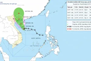
At 5 a.m. on July 5, the center of typhoon Maysak had moved into southern Guangxi Province, China, about 63 kilometers north of Mong Cai. Maximum sustained winds near the storm's center were at level 8 (62–74 km/h), with gusts reaching level 10 (89–102 km/h). The storm was moving north-northeast at a speed of 5–10 kilometers per hour.
The National Center for Hydro-Meteorological Forecasting forecasts that typhoon Maysak will continue to weaken into a tropical depression in the coming hours before degenerating into a low-pressure area.
At around 10 p.m. on July 4, typhoon Maysak made landfall in the Mong Cai area of Quang Ninh Province. After affecting Quang Ninh's coastal areas for more than two hours, the storm reached its peak intensity over land, with maximum sustained winds of level 9 (75–88 km/h) and gusts up to level 11 (103–117 km/h).
Under the direct influence of the storm's circulation, strong winds were recorded across Quang Ninh Province and the northern Gulf of Tonkin. Mong Cai experienced winds of level 9 with gusts reaching level 12 (118 - 133 km/h); Bach Long Vi recorded winds of level 9 with gusts up to level 11; Co To saw level-8 winds with gusts reaching level 10, accompanied by waves of up to 2.25 meters. Cua Ong and Quang Ha both recorded level 8 winds with gusts up to level 9.
From the afternoon of July 4 to the morning of July 5, Quang Ninh experienced heavy to very heavy rainfall. Mong Cai recorded 247.6 millimeters of rainfall during the period.
")
The National Center for Hydro-Meteorological Forecasting warned that although the center of the storm has moved out of the country, its circulation will continue to bring winds of levels 6 (39–49 km/h)–7 (50–61 km/h) with gusts up to level 8 to northeastern Quang Ninh Province.
During the morning and around midday on July 5, the northern Gulf of Tonkin, including Bach Long Vi, Van Don, Co To, and Cat Hai, is expected to experience winds of levels 6–7 with gusts reaching levels 9–10. Sea waves are forecast to reach 2–3 meters, with rough sea conditions. Along the coast of Quang Ninh Province, winds of levels 6–7 with gusts up to level 8 will persist before gradually weakening after 10 a.m.
Regarding rainfall, from the early morning through the end of July 5, the Northern region is expected to continue experiencing moderate to heavy rain, with widespread accumulations of 40–90 millimeters and isolated totals exceeding 120 millimeters. The Northeast is forecast to receive heavy to very heavy rainfall, with widespread accumulations of 100–200 millimeters and some areas expected to record more than 300 millimeters.
The meteorological agency warned that the risk of natural disasters associated with the storm's circulation remains high. Heavy rainfall could trigger flooding in urban areas, industrial parks, and low-lying areas while also increasing the risk of rising water levels on small rivers and streams, flash floods, and landslides in mountainous areas, particularly across the Northeastern provinces.
Residents and local authorities are advised to monitor weather forecasts closely and remain vigilant until rainfall and strong winds have completely subsided.

Weather forecast for regions across the country:
Hanoi will be cloudy with occasional moderate rain during the day and scattered showers and thunderstorms at times overnight. Winds will be southerly to southwesterly at levels 2 (6-11km/h) and 3 (12-19km/h). Thunderstorms may be accompanied by tornadoes, lightning, and strong wind gusts. The lowest temperature is 25–27 degrees Celsius. The highest temperature is 30–32 degrees Celsius.
The Northwest region will be partly cloudy with scattered showers and thunderstorms, with isolated areas experiencing heavy to very heavy rainfall. Winds will be light. Thunderstorms may bring tornadoes, lightning, and strong wind gusts. The lowest temperature is 23–26 degrees Celsius, dropping below 22 degrees Celsius in some areas. The highest temperature is at 30–33 degrees Celsius, exceeding 33 degrees Celsius in isolated locations.
The Northeast provinces will be mostly cloudy with moderate to heavy rain during the day and isolated areas of very heavy rainfall. The northeastern subregion is expected to receive heavy to very heavy rain. At night, scattered showers and thunderstorms will continue, with isolated heavy downpours. Southwesterly to southerly winds are at level 3; along the Quang Ninh coast, morning winds will reach levels 6–7, with gusts up to levels 8–9. Thunderstorms may be accompanied by tornadoes, lightning, and strong wind gusts. The lowest temperature is 24–27 degrees Celsius, falling below 23 degrees Celsius in some mountainous areas. The highest temperature is at 29–32 degrees Celsius.
From Thanh Hoa to Hue, skies will be mostly cloudy. The northern part of the region will experience scattered showers and thunderstorms, with isolated heavy rain, while the southern part will see isolated showers and thunderstorms. Southerly to southwesterly winds are at levels 2–3. Thunderstorms may be accompanied by tornadoes, lightning, hail, and strong wind gusts. The lowest temperature is 25–28 degrees Celsius. The highest temperature is 31–34 degrees Celsius.

The South Central Coast will be partly cloudy with sunny weather during the day. Isolated showers and thunderstorms are expected in the late afternoon and at night. Southwesterly winds are at levels 2–3. Thunderstorms may be accompanied by tornadoes, lightning, hail, and strong wind gusts. The lowest temperature is 24–27 degrees Celsius. The highest temperature is 31–34 degrees Celsius, exceeding 34 degrees Celsius in some areas.
The Central Highlands will be mostly cloudy with isolated showers and thunderstorms. During the late afternoon and evening, scattered showers and thunderstorms are forecast, with isolated heavy rain. Southwesterly winds are at levels 2–3. Thunderstorms may be accompanied by tornadoes, lightning, hail, and strong wind gusts. The lowest temperature is 20–23 degrees Celsius, dropping below 20 degrees Celsius in some areas. The highest temperature is at 26–29 degrees Celsius, exceeding 29 degrees Celsius in isolated locations.
The Southern region will be mostly cloudy with isolated showers and thunderstorms. Scattered showers and thunderstorms are expected during the late afternoon and evening, with isolated heavy rain. Southwesterly winds are at levels 2–3. Thunderstorms may be accompanied by tornadoes, lightning, hail, and strong wind gusts. The lowest temperature is 23–26 degrees Celsius. The highest temperature is 31–34 degrees Celsius.
Ho Chi Minh City will be mostly cloudy with isolated showers and thunderstorms. Scattered showers and thunderstorms are forecast during the late afternoon and evening, with isolated heavy rain. Southwesterly winds are at levels 2–3. Thunderstorms may be accompanied by tornadoes, lightning, hail, and strong wind gusts. The lowest temperature is 25–27 degrees Celsius. The highest temperature is 32–34 degrees Celsius.