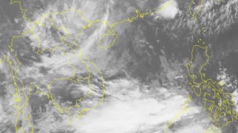
At 4pm yesterday, its eye was centered at 20.2 degrees north latitude and 109.1 degrees east longitude, at 140 kilometers of the eastward of the Bach Long Vi Island.
The National Hydrology Meteorology Forecast Center reported that the tropical depression entered the southeastward of the Gulf of Tonkin with its powerful wind of level 6.
At present, another tropical low pressure zone has been developing into a supper storm named Lan offshore Philippines.
Although typhoon Lan did not enter the East Sea, it is strongly operating of the southwest monsoon in the Gulf of Thailand and the southern region.
Because of its impact, the southern provinces and Ho Chi Minh City have experienced deep cloud and heavy rain.
The mid and south- East Sea including the Paracel Islands, the southern territorial waters from Binh Thuan to Ca Mau, from Ca Mau to Kien Giang maintain showery weather and the southwest monsoon of level 5-9.
By October 16, the natural disaster of torrential rain, flash flood and tropical depression caused 72 dead and 30 missing ones.
Meanwhile, the northern region of Vietnam has experienced the first cold front of the year. The temperature in the northern mountainous region was measured at 15-16 degrees Celsius.
Deputy Director of the National Hydrology Meteorology Forecast Center Mr. Le Thanh Hai said that temperature in the next months of the year is expected to be cooler than the last three years' temperature.
The Vietnamese Young Astronomical Society also said that the forecast for winter 2017 - 2018 would be the coldest temperature during 100 years ago.


