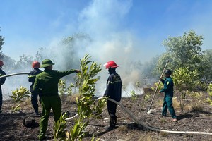
The Central Highlands, defined by its rugged mountainous landscape, experiences frequent landslides during the rainy season, threatening villages and disrupting transportation networks. In recent weeks, intense rainfall has caused landslides across multiple provinces in the region.

In Kon Tum Province, three districts comprising Kon Plong, Tu Mo Rong, and Dak Glei are especially prone to landslides. In Dak La Hamlet in Dak Ring Commune of Kon Plong District, 41 households are currently living in high-risk mountainous areas. According to Chairman Nguyen Thanh Hai of the People’s Committee in Dak Ring Commune, the local government is actively relocating these residents to safer resettlement zones, with financial support provided for new housing.
In Tu Mo Rong District, recent heavy rains triggered landslides along the National Highway 40B, depositing soil onto the roadway. Landslides also struck the Mang Roi bypass road, linking Dak To and Tu Mo Rong districts. Large amounts of unstable earth and rock along the slopes continue to threaten traffic. A retaining wall is cracked, tilted, and at risk of collapsing under further pressure.
Director Phan Muoi of the Kon Tum Department of Construction said that landslides regularly impact major roads during the rainy season, including the Ho Chi Minh Road, the National Highway 40B, the Truong Son Dong Road, and provincial roads including No. 672, 673, 675, 677 as well as routes serving resettlement areas and hydropower projects.
The department has instructed road management units to deploy monitoring teams and ready machinery for swift debris removal to maintain road access.
In Dak Nong Province, severe landslides frequently occur in Bu Krac and Bu Prang 1A villages in Quang Truc Commune of Tuy Duc District. Authorities have declared a natural disaster emergency to accelerate response and recovery efforts. Tuy Duc District is completing a resettlement project to relocate 100 households from high-risk areas to safer housing.
Another critical issue during the rainy season is the structural integrity of dams linked to hydropower and irrigation systems. Deputy Director Le Trung Kien of the Dak Lak Irrigation Sub-Department reported that the province has over 600 irrigation dams, many of which are aging and deteriorating. A recent assessment identified more than 100 structures as unsafe. The department has requested central funding for repairs and upgrades to ensure safety during the rainy season.
Deputy Director Mai Trong Dung of the Dak Lak Department of Agriculture and Rural Development stated that local authorities have been directed to allocate personnel, materials, and equipment for emergency response to maintain road access during storms. Authorities are also reviewing vulnerable infrastructure and dams to develop contingency plans that protect both structures and downstream communities.
To ensure the safety of Gia Lai Province’s 31 hydropower plants during the rainy season, Director Pham Van Binh of the Gia Lai Department of Industry and Trade said inspection teams have been formed. These teams will evaluate dam operation protocols, maintenance practices, disaster response strategies, and protective measures. Similarly, the Kon Tum People’s Committee has approved protection plans for dams and reservoirs at six hydropower plants in Kon Plong, Kon Ray, Dak To, and Dak Ha districts.
Elsewhere in the Northern region, Yen Bai Province was flooded due to heavy rains. As of the afternoon of June 25, a tropical depression over the northern East Sea had moved to approximately 18.4°N, 113.6°E—about 300km northeast of the Hoang Sa (Paracel) Islands—with peak winds reaching level 6, gusting to level 8. The storm system is expected to strengthen on June 26 to level 6–7 with gusts up to level 9, affecting the northwestern East Sea and northern Hoang Sa.
By the afternoon of June 26, it is forecast to continue moving northwest and weaken over the waters east of China’s Leizhou Peninsula. By June 27, it is expected to downgrade to a low-pressure zone over southern Guangxi in China.
Due to the system’s indirect effects, some northern regions of Vietnam experienced heavy rains on June 25, worsening weather conditions in the Northwest. Prolonged downpours caused severe flooding in Yen Bai City, with streets such as Le Van Tam, Kim Dong, Quang Trung, and Dien Bien submerged up to 0.5 meters—some areas flooded to the base of homes. Rainfall measured at Lieu Do reached 317.6mm, Muong Lai 293.8mm and Minh Quan 164.4mm.
The National Center for Hydro-Meteorological Forecasting and the Department of Dyke Management and Disaster Prevention warned that on June 26–27, some areas in the South could receive over 80mm of rainfall, while the Viet Bac region may see localized downpours exceeding 150mm.