")
The Japan Meteorological Agency has also confirmed the appearance of the tropical low-pressure system.
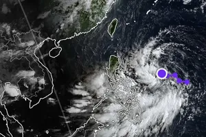
According to the National Center for Hydrology Meteorology Forecasting, previously, on July 19 morning, a low-pressure zone in the eastern waters of the middle of the East Sea grew into a tropical low-pressure system.
The tropical low-pressure system was centered at approximately 14 degrees north latitude and 118 degrees east longitude, moving slowly northwest at an hourly speed of five to ten kilometers.
It is forecast that the tropical depression will move northwest and west-northwest in a row. Under its impact, the eastern part of the northern and middle of the East Sea and the northeastern waters of the Paracel Islands will see thundery showers, blustery winds, big waves and rough seas.
International meteorological agencies predicted that the tropical low-pressure system has a 90 percent chance of developing into a typhoon and a ten percent possibility of making landfall in Guangdong Province, China.
In addition, another tropical low-pressure system has formed in the east of the Philippines. It is forecast to intensify and become the strongest storm since the beginning of the year.


)


