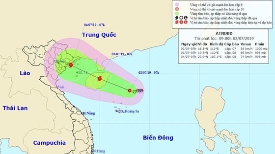
In the early morning, this system was located at 190 kilometers of the East Sea’s northeastern territorial waters and the Paracel Islands, with maximum sustained winds of level 6-9 near the center.
Within the next 24 hours, the tropical depression is expected to move the west- northwest at 10 kilometers an hour and is able to turn into a typhoon.
By 1pm tomorrow, it will be at the Hainan Island’s eastern territorial water with a violent wind of 60- 75 kilometers.
Within later 48 hours, the storm will continue moving the west- northwest and be located at the territorial waters from Quang Ninh to Nam Dinh.
Operation of the tropical low pressure along with high sea surface temperature will be favorable condition for the tropical typhoon to make landfall in Vietnam, triggering heavy downpours, violent flashflood, landslide in the Northern and North- Central regions.
Additionally, because of an impact of the southwest monsoon, the southern territorial waters from Binh Thuan to Ca Mau will possibly face risks of scattered rains, thunderstorms, violent wind, huge waves and rough sea.


