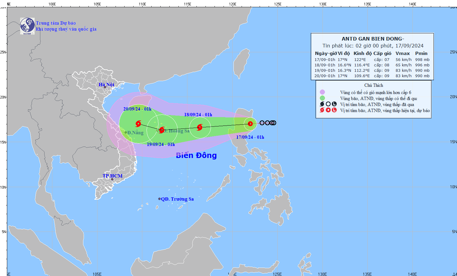
As of the early morning of September 17, updates from the National Center for Hydro-Meteorological Forecasting show the tropical depression was over Luzon Island in the Philippines, with sustained winds of 50-61 km/h (level 7) and gusts reaching level 9. It was moving westward at a speed of 15 km/h.
By September 18, the tropical depression is expected to enter the East Sea and intensify into a storm. The storm’s center is forecasted to be in the Northern part of the East Sea by morning, approximately 420 km East of the Paracel Islands, with wind speeds reaching level 8 and gusts up to level 10.
Yesterday, the Japan Meteorological Agency (JMA) and several storm warning centers suggested that the storm could head toward Northern Vietnam. However, the latest update from the JMA indicates that it is likely to shift course toward the North Central Coastal of Vietnam.
While meteorologists believe that Typhoon No.4 is not as strong as Typhoon No.3 (Yagi), it still poses significant forecasting challenges for international weather agencies. There remains a high likelihood that its path will change in the upcoming forecasts.
Over the next 48-72 hours, the storm is expected to continue moving West-Northwest at a speed of 10-15 km/h, nearing the Paracel Islands and bringing adverse weather to several maritime areas.
Vietnamese meteorologists predict that the storm may directly impact Central Vietnam, bringing heavy rain and strong winds. Some experts suggest a high likelihood of the storm making landfall in Central Vietnam, as a cold air mass is expected to move southward from Northern Vietnam after September 19, pushing the storm toward the South.
The forecast for 1 a.m. on September 18 shows the storm moving West-Southwest at around 25 km/h as it enters the East Sea, with wind speeds of level 8 and gusts up to level 10. By 1 a.m. on September 19, the storm is expected to continue moving West-Southwest at 15-20 km/h, approaching the Paracel Islands with wind speeds reaching level 9 and gusts up to level 10.
Starting this afternoon, September 17, the Northeastern region of the East Sea will experience strong winds at levels 6-7, with winds near the storm’s center reaching level 8 and gusts up to level 10. Sea waves will rise to 3-5 meters, causing rough seas.
On land, Northern and Central Vietnam will be mostly sunny today, with scattered showers and thunderstorms expected by late afternoon and evening, and some areas may experience moderate to heavy rainfall.
In the Central Highlands and Southern Vietnam, widespread heavy rainfall is expected over the next two days, with rainfall totals ranging from 40-80 mm, with some areas exceeding 150 mm, increasing the risk of localized flooding and landslides.


)


