However, the storm’s western circulation could bring strong winds and high waves to the eastern waters of the northern East Sea over the next one to two days.
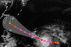
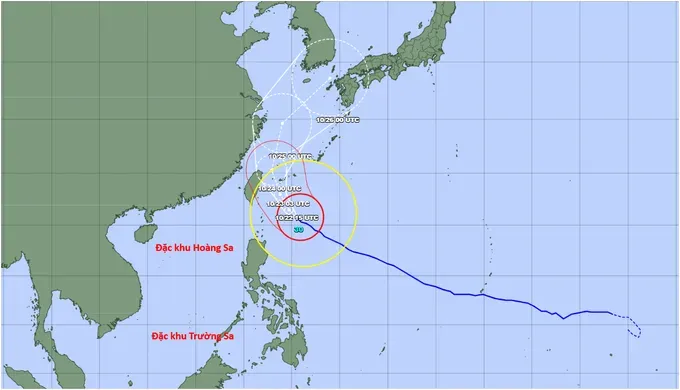
Around noon on October 22, Champi was located at approximately 20.6 degrees north latitude and 125.7 degrees east longitude, packing winds of level 16 (184–201 km/h), with gusts exceeding level 17 (202–221 km/h). The storm had weakened by one level compared with October 21. It was approximately 500 kilometers southeast of Taiwan (China).
Over the next 24 hours, Champi is forecast to move northwest at an average speed of 15–20 kilometers per hour. By the morning of October 23, as it approaches the waters east of Taiwan (China), the storm is expected to weaken to levels 14 (150-166 km/h) – 15 (167-183 km/h), losing its super typhoon status.
Around October 25, Champi is forecast to turn north before heading northeast toward Japan. The storm is expected to continue weakening, potentially dropping to level 8 (62–74 km/h), with gusts reaching level 10 (89–102 km/h), as it approaches Japan.
According to the Japan Meteorological Agency, Champi will not enter the East Sea. However, while the storm remains powerful at level 16, with gusts exceeding level 17, its broad circulation could bring winds of levels 6 (39–49 km/h)—7 (50–61 km/h), gusting at levels 8–9 (75–88 km/h), and waves of 2–4 meters to the eastern waters of the northern East Sea over the next one to two days.
In the northeastern waters of the northern East Sea, winds could reach levels 8–9, with gusts of levels 10–11 (103–117 km/h), and waves of 4–6 meters, resulting in very rough seas.
The National Center for Hydro-Meteorological Forecasting has assigned a level 2 natural disaster risk warning to the eastern waters of the northern East Sea and a level 3 to its northeastern waters.