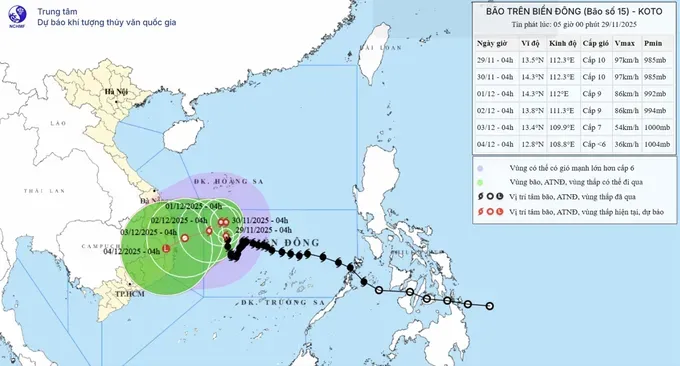
According to updates from the National Center for Hydro-Meteorological Forecasting, early on the morning of November 29, the center of typhoon No. 15 was located at about 13.5 degrees North latitude and 112.3 degrees East longitude, around 310 kilometers northwest of Song Tu Tay (Southwest Cay) Island. The storm has weakened to level 9–10 (equivalent to 75–102 kilometers per hour), with gusts up to level 13, and is currently moving in a north-northwesterly direction at 5–10 kilometers per hour.

From early November 29 to early November 30, typhoon No. 15 is forecast to move north-northwest at 5–10 kilometers per hour. By around 4 a.m. on November 30, the storm’s center will be over the northwestern waters in the middle of the East Sea, about 330 kilometers east of the coast of Gia Lai and Dak Lak provinces, maintaining intensity at level 9–10 with gusts up to level 13.
From the morning of December 1 to the morning of December 2, the storm will shift west-southwest and slow to 3–5 kilometers per hour. By the morning of December 2, its center will be around 230 km east of the Gia Lai–Dak Lak coastline, and it will further weaken to level 8–9, with gusts up to level 12.
After that, the storm is expected to continue moving west-southwest at 3–5 kilometers per hour and gradually weaken further.
According to forecast models from the National Center for Hydro-Meteorological Forecasting, typhoon No. 15 will continue changing direction and staying over the sea for several days, with a strong chance of making landfall along the South Central Coast and affecting inland areas through its circulation.
Fast-moving tropical depression heads into the southern East Sea
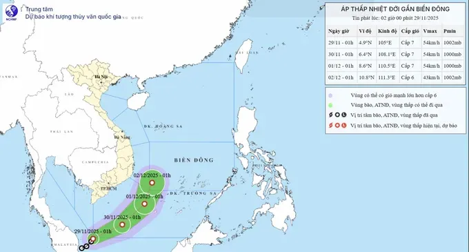
In the meantime, an unusual tropical depression near Malaysia continues moving toward the southern East Sea.
According to the National Center for Hydro-Meteorological Forecasting, early on November 29, the center of this tropical depression was located at approximately 4.9 degrees North latitude and 105 degrees East longitude, over the waters east of Malaysia. The system has strengthened to level 6–7 (equivalent to 39–61 kilometers per hour), with gusts up to level 9, and is moving northeast at about 15 kilometers per hour.

From the morning of November 30 to the morning of December 1, the tropical depression is expected to maintain a northeastward track at around 15 kilometers per hour. By 1 a.m. on December 1, its center will be over the northwestern waters of the southern East Sea, maintaining intensity at level 6–7 with gusts up to level 9.
Over the next two days, the tropical depression will move north-northeast at 10–15 kilometers per hour and gradually weaken.
In the southwestern waters of the southern East Sea, winds are expected to strengthen to level 6–7 with gusts up to level 9, and waves will reach 2.5–4 meters. The sea will be very rough. Vessels operating in these hazardous areas may be affected by thunderstorms, strong winds and huge waves.


