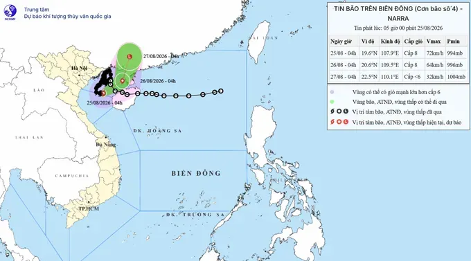
According to the National Center for Hydro-Meteorological Forecasting, at 4 a.m. on August 25, the storm's center was located at approximately 19.6 degrees north latitude and 107.9 degrees east longitude, over waters south of Bach Long Vi Special Zone. The storm had weakened to level 8 (62–74 km/h), with gusts reaching level 10 (89–102 km/h), and was moving eastward at a speed of 5–10 km/h.
From this morning through the morning of August 26, the storm is forecast to move northeastward at 5–10 km/h toward the eastern Gulf of Tonkin. By early tomorrow morning, its center is expected to be about 200 km east-northeast of Bach Long Vi Special Zone. Maximum sustained winds are forecast to remain at level 8, with gusts reaching level 10.
From the morning of August 26 to the morning of August 27, the storm is forecast to move north-northeastward at around 10 km/h, heading toward the mainland of Guangxi Province, China.
According to the meteorological authorities, weather conditions in the Northern region have gradually improved, with floodwaters on rivers beginning to recede. However, scattered showers and thunderstorms persisted in some areas overnight on August 24 and early on August 25. The area from Thanh Hoa to Ha Tinh experienced moderate to heavy rain and thunderstorms, with some locations seeing very heavy rainfall.
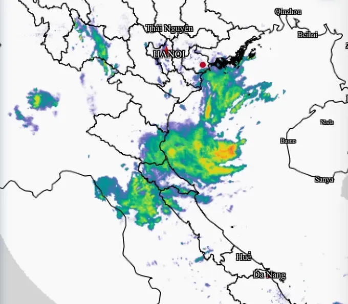
Rainfall recorded from 7 p.m. on August 24 to early August 25 included 97.2 mm at Sam Muu 1 Station in Dien Bien, 80 mm in Chieng Hac, Son La Province, 59 mm in Suoi Giang, Lao Cai Province, 69 mm in Thac Muoi, Nghe An Province, and 57.2 mm at Ho Xuan Hoa in Ha Tinh Province.
From early August 25 through the end of the day, the area from Thanh Hoa to Ha Tinh is expected to continue experiencing moderate to heavy rain and thunderstorms, with rainfall generally ranging from 20 to 40 mm and exceeding 80 mm in some locations.
Other parts of the Northern region are also forecast to see scattered showers and thunderstorms on August 25, with rainfall generally ranging from 10 to 30 mm and exceeding 80 mm in some areas. Heavy rain from Thanh Hoa to Ha Tinh is expected to gradually subside from the night of August 25.
The Southern Regional Hydro-Meteorological Center forecasts that from August 25 to 27, southern provinces and cities will receive less rainfall than recently. Mornings will be sunny, with sunshine intensifying rapidly around midday and producing rather hot and humid conditions.
At around 2 p.m., convective clouds are expected to develop and bring rain, although rainfall will not be widespread and is unlikely to last long.














)








