")
Accordingly, the Ho Chi Minh City Department of Planning and Architecture has been assigned to lead and coordinate with relevant agencies in proposing a comprehensive plan for the Khanh Hoi Port area. The plan prioritizes allocating land for green spaces and developing a multifunctional park to serve the community, while also studying the upgrade and expansion of Nguyen Tat Thanh Street to ensure smooth traffic and convenience for residents.
Regarding the legal status of the land, under the previously approved 1/2000-scale subdivision plan for Ho Chi Minh City's existing central area and the 1/500-scale planning scheme for the District 4 port sub-area, Khanh Hoi Port is designated as a multifunctional urban area. The main functional zones include public facilities, green parks, residential areas, mixed-use complexes, commercial and office services, and cultural and entertainment spaces, as well as urban transport and technical infrastructure systems.
Regarding the current state of the land, it includes Nha Rong Wharf, Ho Chi Minh Museum (Ho Chi Minh City Branch), the offices of Saigon Port Company, a series of old warehouses built between 1925 and 1929, as well as the pier and a water tower.
According to the Department of Planning and Architecture, the proportion of green park areas in the city’s inner districts remains far below planning standards. The proposed planning scheme prioritizes allocating land for green spaces and establishing a multifunctional community park, integrating park amenities to enhance residents’ quality of life.
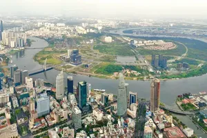
Based on the city's adjusted master plan to 2040, with a vision for 2060, approved by the Prime Minister under Decision No. 1125/QD-TTg, and following directives from the Ho Chi Minh City People’s Committee, the Department of Planning and Architecture has preliminarily proposed a master plan for the Khanh Hoi Port site, covering a research area of approximately 31.5 hectares.
The site is planned to serve as a green park area, a recreational space for residents, and an international passenger port. Land use allocation (for the entire area, excluding Nha Rong Wharf, Ho Chi Minh Museum and defense land) is proposed as follows: approximately 60 percent for green parks, 20 percent for public facilities, and 20 percent for the international port.
The proposed expansion of Nguyen Tat Thanh Street is oriented toward the Khanh Hoi Port area. The Department of Construction will study and propose the specific road width to ensure the infrastructure meets future regional demands.