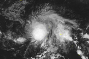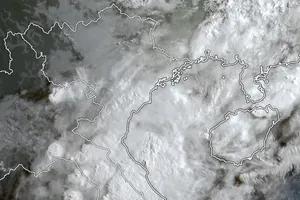
According to the National Center for Hydro-meteorological Forecasting, the low-pressure area was formed on a low-pressure trough passing through the North East Sea area this morning.
At 7 am this morning, the low pressure area was located at about 15.5 - 16.5 degrees North latitude and 117.5 - 118.5 degrees East longitude.
It is forecasted that in the next 24 hours, the low-pressure area will move slowly to the northwest and continue to be strong. Due to the influence of the low-pressure trough connected to the low-pressure area, there will be heavy rain today in the North East Sea and Middle East Sea (including the waters of the Paracel Islands) and there will be showers and strong thunderstorms in the Gulf of Tonkin; hence, the Gulf of Tonkin will experience winds gusting to level 7-8.
In the South East Sea area (including the waters of Truong Sa archipelago), the sea from Binh Thuan to Ca Mau will experience rough sea and winds gusting to level 5-7 and waves as high as three meters.
During thunderstorms, cyclones and strong gusts are highly like to be.
Meteorologists warned that in the next 1-2 days, the low-pressure area is likely to develop into a tropical depression. They also noted that in the coming days, there will be another tropical depression entering the East Sea from outside the Pacific Ocean, which may strengthen into a storm.
These tropical cyclones will trigger the southwest monsoon in the country’s southern seas, so the weather in Phu Quoc and many tourist resorts in the South and Central Highlands will be bad, people were advised to update weather information.

