Following an announcement from the National Center for Hydro-Meteorological Forecasting that a low-pressure system south of the Hoang Sa (Paracel) Archipelago had intensified into a tropical depression, Deputy Minister Nguyen Hoang Hiep dispatched a telegram to People’s Committees in coastal provinces from Quang Ninh to Khanh Hoa yesterday evening.
The Ministry’s directive outlines several critical preparedness measures:
- Vessel Safety: A comprehensive inspection of all fishing vessels is mandated to ensure their readiness for severe weather.
- Evacuation Plans: Provinces must finalize and prepare to execute evacuation plans for residents in low-lying and coastal areas.
- Infrastructure Protection: Authorities are instructed to secure critical infrastructure, including dikes and reservoirs, against potential flooding and structural damage.
- Public Information: Timely and accurate weather updates must be disseminated to the public to ensure widespread awareness and preparedness.
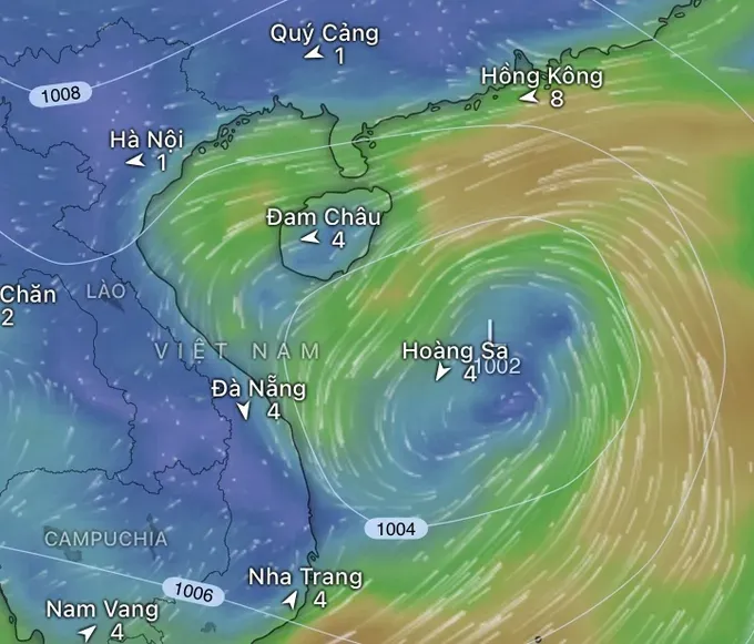
The National Center for Hydro-Meteorological Forecasting has warned of significant rainfall and thunderstorms from August 16 through August 18. The Northern and Central regions are expected to bear the brunt of the storm, with rainfall projections as follows:
- Northeast, Thanh Hoa, and Nghe An: 50–120mm, with some areas potentially receiving over 250mm.
- Northern Mountainous Regions: 30–80mm, with certain locations exceeding 150mm.

At the same time, the Central Highlands and Southern regions are forecast to have moderate to heavy rain with thunderstorms, with rainfall of 20–50mm, locally over 100mm. Ha Tinh and Quang Tri, in particular, are expected to experience moderate to heavy rain on August 17, with rainfall of 30–70mm, locally exceeding 120mm. Other areas, including the Northwest, the region from Ha Tinh to Hue, and the South Central coastal provinces, will also see scattered showers and thunderstorms, with localized heavy rain ranging from 10–30mm, locally over 80mm.
From the night of August 18 to August 19, the Northern region and Thanh Hoa will continue to see moderate to heavy rainfall with thunderstorms, with localized very heavy rain. Rainfall is expected to range from 30–80mm, with some areas exceeding 150mm.
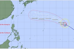
Earlier, the National Center for Hydro-Meteorological Forecasting reported that on the evening of August 16, a low-pressure area over the southern waters of the Hoang Sa (Paracel) Archipelago intensified into a tropical depression.
The center of the tropical depression was located at 16°N latitude and 112.8°E longitude, with wind strength reaching level 6, gusting to level 8, moving northwest at approximately 10 km/h.
Forecasts indicate that within the next 24 to 72 hours, the tropical depression will continue moving northwest. By the evening of August 17, its center is expected to be about 60 km southeast of Hainan Island (China), with an intensity of level 6–7, gusting to level 9.
On August 18, the tropical depression is projected to move further north into the Gulf of Tonkin, maintaining an intensity of level 6, gusting to level 8.
The National Center for Hydro-Meteorological Forecasting has issued warnings that the northwestern part of the East Sea and the Hoang Sa (Paracel) area will experience thunderstorms, strong winds of level 6–7, gusting to level 8–9, and sea waves 2 to 3.5 meters high. In the northern part of the Gulf of Tonkin, from the morning of August 18, winds are expected to gradually strengthen to level 6, gusting to level 8, with waves 2 to 3 meters high, causing rough seas.