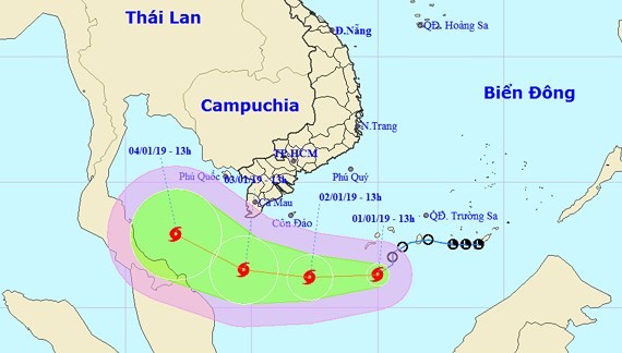
At 4 a.m. this morning, the typhoon was centered 460 kilometers southeast of southern provinces and 360 kilometers off Con Dao island, Ba Ria-Vung Tau province.
Strongest winds near the eye of the storm reached level 8, moving 60-75 kilometers an hour.
In the next 24 hours, the storm will move west northwest at 15 kilometers an hour. By 4a.m. on January 3, it will locate 200 kilometers south of Ca Mau Cap in the southernmost point of Vietnam and 270 kilometers south southwest of Con Dao.
Under influence of the storm and a northward cold front, the southern part of the East Sea has been rough and choppy including the waters off provinces from Quang Ngai to Binh Thuan and from Ba Ria-Vung Tau to Ca Mau.


