At 4 p.m., the tropical depression was located at around 19.4 degrees North latitude and 108.4 degrees East longitude over the southern Gulf of Tonkin, with maximum sustained winds near its center at Force 7 and gusts up to Force 9. It was moving eastward at about 10 kilometers per hour.
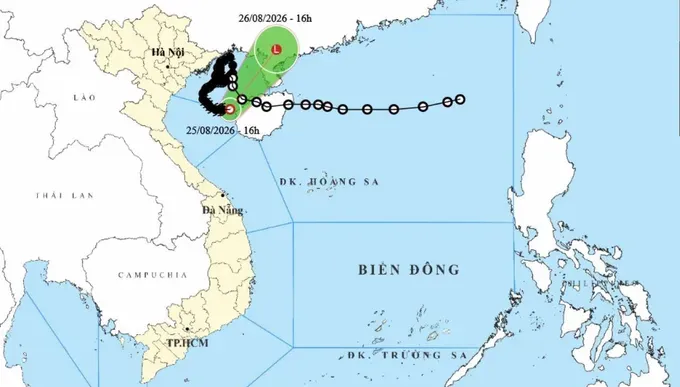
Earlier, at 2 p.m., the center had forecast that typhoon No. 4 would weaken into a tropical depression by 1 p.m. on August 26 and further weaken into a low-pressure area over China’s Guangxi Province on August 27.
Typhoon No. 4, internationally named Narra, developed from a tropical depression over the northern East Sea before entering the Gulf of Tonkin on August 21 and strengthening into a typhoon later that day.
The storm repeatedly changed direction and intensity while over the Gulf of Tonkin. On August 22, the storm reached Force 8 with gusts up to Force 10, bringing heavy rain to many areas in northeastern Vietnam.
On August 24, the storm strengthened to Force 9 with gusts up to Force 11 over waters north of Bach Long Vi Special Zone before moving slowly eastward and weakening from the morning of August 25.













)








