From August 22 through the night of August 24, the Quang Ninh and Hai Phong areas are forecast to receive 250–350 mm of rainfall, with localized totals exceeding 600 mm. Heavy downpours are expected to persist beyond August 24.
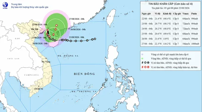
As of 4:00 a.m. on August 22, the eye of typhoon Narra was centered at approximately 21.4 degrees North latitude and 108.4 degrees East longitude, positioned over the waters off Quang Ninh and Hai Phong, roughly 150 km north-northeast of Bach Long Vi Island. Maximum sustained winds near the storm's center reached level 8 (62–74 km/h), with gusts up to level 10 (89–102 km/h). The storm is creeping northward at a speed of approximately 5 km/h.
Due to the impact of the storm, Bach Long Vi Island recorded strong winds of level 8, gusting to level 9, while Co To Island reported level 6 (39–49 km/h) winds, with gusts reaching level 9 (75- 88 km/h).
According to the National Center for Hydrometeorological Forecasting, from 4 a.m. on August 22 to 4 a.m. on August 23, the storm is forecast to move southward at a speed of about 3 km/h over the northern Gulf of Tonkin, approximately 170 km east of Hai Phong and 80 km north-northeast of Bach Long Vi Special Zone.
From 4 a.m. on August 23 to 4 a.m. on August 24, the storm is expected to shift south-eastward at 3-5 km/h, about 110 km east of the Bach Long Vi special zone and 230 km east-south-east of Hai Phong.
From 4 a.m. on August 24 to 4 a.m. on August 25, the storm is forecast to continue shifting east-north-eastward at 3-5 km/h, approximately 200 km east-north-east of Bach Long Vi Special Zone, while maintaining winds of level 8, with gusts reaching level 10.
Afterwards, the storm is likely to move north-northeastward at 3-5 km/h and gradually weaken into a tropical depression.

At sea, both currently and in the coming days, the Gulf of Tonkin, including the Bach Long Vi, Van Don, Co To and Cat Hai special zones, as well as Hon Dau Island, is expected to experience winds of level 6-7 (50–61 km/h), increasing to level 8 near the storm's center, with gusts reaching level 11 (103–117 km/h). Waves may rise to 2- 4 meters, resulting in very rough seas.
Strong winds and high waves could capsize, sink, or damage fishing vessels, cargo ships, tourist boats, aquaculture cages and rafts, vessel anchorage areas, and coastal infrastructure.
On land, coastal areas of Quang Ninh and Hai Phong may experience winds of level 6-7, with gusts of level 8-9, potentially causing damage to roofs and temporary structures, uprooting or breaking trees and billboards, and disrupting power supply, telecommunications and transportation.
From August 22 through the night of August 24, the Northeastern region and the southern part of Phu Tho Province and Thanh Hoa are forecast to receive 100-200 mm of rainfall, with some areas seeing more than 400 mm. Quang Ninh and Hai Phong may receive 250-350 mm, locally exceeding 600 mm, while Lang Son and Bac Ninh could see 200-300 mm, with localized totals surpassing 500 mm. Rainfall is likely to continue beyond the night of August 24.











)