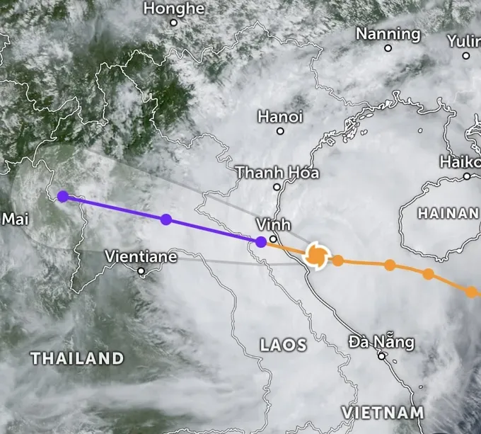
According to the National Center for Hydro-Meteorological Forecasting, as of the morning of August 25, the typhoon remained strong as it approached the coastal area from Thanh Hoa to Ha Tinh, with winds of force 14 (150-166 kilometers per hour) and gusts up to force 17 (220 kilometers per hour)
In Hainan Island (China), more than 400mm of rain poured down within 24 hours, accompanied by force 14–17 winds, prompting the emergency evacuation of around 20,000 residents.
In Vietnam, coastal meteorological stations from Quang Ninh to Quang Tri recorded winds of force 6–7 (49-61 kilometers per hour), gusting to force 9–10 (88- 102 kilometers per hour). Meanwhile, heavy rain exceeded 150mm in some areas of Ha Tinh and Quang Tri provinces.

As of 10 a.m. on August 25, the eye of typhoon No. 5 was located at approximately 18.4 degrees North latitude, 106.8 degrees East longitude, about 120 kilometers east-southeast of Nghe An, 100 kilometers east of Ha Tinh and 130 kilometers east-northeast of northern Quang Tri.
Maximum sustained winds near its eye reached category 13–14 (134–166 kilometers per hour), with gusts up to category 16 (201 kilometers per hour). The typhoon is forecast to continue moving west-northwest at roughly 15 kilometers per hour over the next three hours.
The National Center for Hydro-Meteorological Forecasting reported that as typhoon Kajiki moves through the waters off Ha Tinh and Thanh Hoa, it maintains a strength of force 14 with gusts up to force 16. The system is forecast to slightly decrease its intensity to force 13–14 as it nears the coast.
The strongest winds on land are forecast for the area from southern Thanh Hoa to northern Ha Tinh, with sustained winds of force 12–14, gusting to force 15–16, and a radius of winds above force 12 extending about 50 kilometers per hour.
Meteorologists indicate that from now until the afternoon, Kajiki will hold force 14 winds with gusts of 15–16 as it crosses offshore Ha Tinh–Thanh Hoa, weakening slightly to force 13–14 near the Ha Tinh–Nghe An coast.
The northern Thanh Hoa and inland areas are expected to experience winds of force 8–9 (74-88 kilometers per hour), with gusts reaching wind forces of 10–11 (102-117 kilometers per hour). The intensity will decrease to force 6–7 (49-61 kilometers per hour) as they approach the Laos border.
The strongest winds are forecast from noon to around 6 p.m., said a representative from the National Center for Hydro-Meteorological Forecasting.
The National Center for Hydro-Meteorological Forecasting also reported that forecast models from Vietnam, Japan and Hong Kong (China) all predicted wind force 13–14, with gusts locally up to Force 14, as the typhoon makes landfall in Vietnam.


