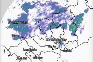
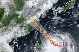
As of 4 a.m. on November 26, the storm’s center was located at 12.2 degrees North latitude and 119.1 degrees East longitude, roughly 540 kilometers east of Song Tu Tay Island (Southwest Cay), part of the Spratly Archipelago. Maximum sustained winds near the core reached category 8 (equivalent to 62 to 74 kilometers an hour, with gusts up to category 10.

The National Center for Hydro-Meteorological Forecasting said Koto is expected to maintain its northwestward trajectory through November 27 morning at a speed of 20 to 25 kilometers an hour, while likely strengthening to category 10, with gusts up to category 13.
By early November 27, the center of the storm is projected to be positioned over the middle of the East Sea, about 200 kilometers northeast of Southwest Cay Island.
From Thursday (November 27) to Friday (November 28), the storm is forecast to veer west-southwest, slowing to 5 to 10 kilometers an hour but potentially intensifying further to category 11, with gusts reaching category 14.
Koto is expected to continue moving westward from Friday to Saturday (November 29), maintaining the same intensity. By then, meteorologists anticipate the storm’s center will lie over the western reaches of the middle of the East Sea, approximately 250 kilometers west-northwest of Southwest Cay.
The national weather agency warned that by November 26, the middle of the East Sea, including the northern waters of the Spratly Archipelago, would experience winds of categories 6 to 7, rising to categories 8 to 10 nearer the storm’s center, with gusts up to category 13.
Conditions are projected to worsen midweek. On November 27 and November 28, the region could see winds of force 11, gusting to 14, along with waves reaching seven to nine meters.
Officials cautioned that vessels operating in these waters face risks from severe thunderstorms, powerful gusts and extremely rough seas.


)