")
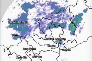
According to the National Center for Hydro-Meteorological Forecasting, as of the morning of November 27, the center of typhoon Koto was located about 190 km north of Song Tu Tay Island. The typhoon has strengthened from level 10 (89–102 km per hour) to level 12 (118–133 km per hour), with gusts up to level 15 (167–183 km per hour), moving west-northwest at a speed of around 15 km per hour.
The National Center for Hydro-Meteorological Forecasting forecasts that from the morning of November 27 to the morning of November 28, typhoon Koto is likely to shift direction from west-northwest to west-southwest and gradually slow to around 5–10 km per hour. By the morning of November 28, the typhoon's center is expected to be over the western waters of the central East Sea, approximately 190 km northwest of Song Tu Tay Island, maintaining level 12 intensity with gusts up to level 15 (167–183 km per hour).
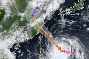
From the morning of November 28 to the morning of November 29, Koto is expected to continue shifting west-northwest before turning northwest at a speed of about 5 km per hour. By the morning of November 29, its center will be over the western waters of the central East Sea, with intensity reduced to level 11 (103–117 km per hour) and gusts up to level 14 (150–166 km per hour).
From the morning of November 29 to the morning of November 30, the typhoon will mainly move north-northwest at a slow speed of 3–5 km per hour over the same area, further weakening to level 10 (89–102 km per hour) with gusts up to level 13 (134–149 km per hour).
Meteorological authorities forecast that from around November 30 to December 1, the typhoon will move north-northwest slowly before turning west-northwest at a speed of approximately 3–5 km per hour, continuing to gradually weaken.
According to Mr. Hoang Phuc Lam, Deputy Director of the National Center for Hydro-Meteorological Forecasting, Koto is characterized by very slow movement, which allows it to persist over the sea for an extended period. He noted that in the early days of December, the typhoon may still not have dissipated.
The Deputy Director of the National Center for Hydro-Meteorological Forecasting also reported that, according to meteorological data, the 2025 typhoon season is not yet over. In December, at least one more typhoon or tropical depression is expected to form over the East Sea following typhoon Koto. As it is the late season, storms or tropical depressions occurring during this period are more likely to make landfall or affect the South Central and Southern regions of Vietnam.


)