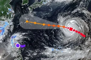
The National Center for Hydro-meteorological Forecasting reported that as of 4:00 a.m. local time on August 25, the eye of typhoon Kajiki was located near 18.3 degrees North latitude and 107.7 degrees East longitude, about 220 kilometers from Nghe An, 200 kilometers off Ha Tinh and 180 kilometers north of Quang Tri.

Maximum sustained winds near the storm’s center remained at 150 kilometers per hour with gusts up to 200 kilometers per hour.
The storm’s massive cloud shield has already reached inland areas.
Coastal stations in Central and Northern Vietnam have reported strong winds since early morning.

Observations recorded gusts up to 74 kilometers per hour on Bach Long Vi Island, 83 kilometers per hour on Co To, 76 kilometers per hour at Bai Chay, 80 kilometers per hour on Hon Ngu and 78 kilometers per hour on Con Co.
From late night into the morning of August 25, typhoon Kajiki continued tracking west-northwest at around 20 kilometers per hour. The storm is expected to bring life-threatening winds, torrential rainfall and dangerous seas to provinces from Nghe An to Quang Tri over the next 24 hours.
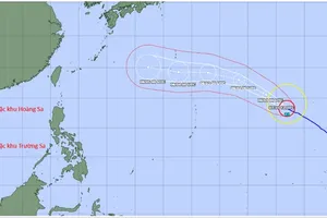
The National Center for Hydro-meteorological Forecasting reported that this morning, typhoon Kajiki continued moving quickly west-northwest at about 20 kilometers per hour. The storm is expected to make landfall from Thanh Hoa to northern Quang Tri by late Monday, August 25.
Meteorologists have issued a level 4 disaster risk warning, the highest alert for coastal and offshore areas from Thanh Hoa to Quang Tri, including Hon Ngu Island and Con Co Island.
With wind gusts up to 200 kilometers per hour expected at landfall, typhoon Kajiki (storm No. 5) poses an extreme danger. The storm is likely to unleash torrential rainfall, triggering flash floods and landslides in mountainous areas, and widespread flooding across provinces in North-Central Vietnam.