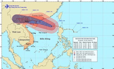
According to the National Hydro Meteorological Forecasting Center, Typhoon Kaitak is now centered in the East Sea and preparing to make landfall in China and vent its fury in the northern mountainous areas of Vietnam.

By 7am this morning, August 16, the storm was located 610 kilometers off Hoang Sa (Paracel) Islands. Wind gales near its center reached level 11-12 moving at 103-133 kilometers an hour.
The storm will move west and northwestwards at 20-25 kilometers an hour and continue to intensify in the next 24 hours.
By 7am on August 17, it will position 440 kilometers east southeast of Mong Cai City in Quang Ninh Province. Strongest winds near the eye of the storm will increase to level 12-13 to blow at 118-149 kilometers an hour.
Kaitak will then skirt the south coast of Guangxi Province in China at 20-25 kilometers an hour and move into the northern mountainous areas of Vietnam and gradually weaken into a tropical low pressure system by August 18.
The typhoon will trigger southwesterly winds on waters off Binh Thuan to Ca Mau Provinces and the southern parts of the East Sea including Truong Sa (Spratly) Islands.

)


