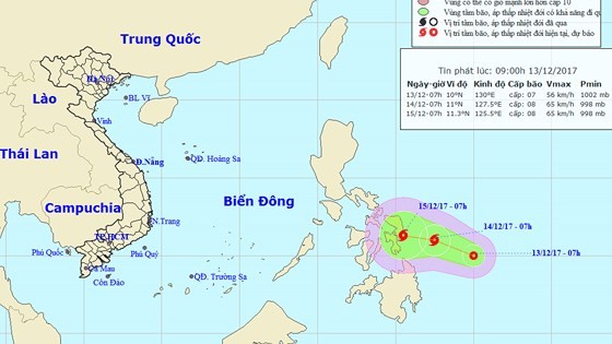
At 7am, its eye was centered at 10 degrees north latitude and 130 degrees east longitude, at around 500 kilometers of the coastal mid of the Philippines. The strongest wind near the center gusted at 40- 60 kilometers an hour.
The tropical depression is going to move the west- northwestwards at a speed of 10-15 kilometers per hour, and it is expected to develop into the typhoon.
By 7am tomorrow, it is forecast to be at around 250 kilometers of the coastal mid of the Philippines with its wind speed of 60- 75 kilometers an hour.
Within next 24- 48 hours, the tropical storm is going to move the westwards at 5- 10 kilometers.
Because of an influence of the ongoing cold air, the northeast territorial water of the East Sea saw powerful wind of level 6-8.
By December 16, strong operation of cold air mass in the Gulf of Tonkin and the central offshore waters will be able to bring power wind of level 6-9 in the southern region, and monsoon of level 7-10 and se rough in the northern and the mid – East Sea.