")
The storm is forecast to maintain winds of Level 8 (62–74 km/h), with gusts reaching Level 10 (89–102 km/h), as it moves north-northwestward toward the Gulf of Tonkin on July 5, bringing heavy to very heavy rainfall to the Northeastern region and Thanh Hoa Province.
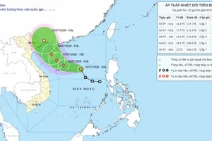
At 4:00 a.m. on July 3, the storm's center was located at approximately 17.3 degrees North latitude and 110.1 degrees East longitude, over the Northwestern waters of Hoang Sa Special Zone, about 120km south of China’s Hainan Island. Maximum sustained winds near the storm's center reached Level 8, with gusts of up to Level 10. The storm was moving westward at around 10km/h.
By 5:00 a.m. on July 3, the storm's center was estimated at approximately 17.4 degrees North latitude and 110.1 degrees East longitude, about 110 km south of Hainan Island. Maximum sustained winds remained at Level 8, with gusts reaching Level 10. Over the following three hours, the storm was forecast to move northwestward at a speed of approximately 5–10km/h.
According to the forecast, by 4:00 a.m. on July 4, the storm is expected to move north-northwestward at 10–15km/h, reaching approximately 19.5 degrees North latitude and 108.8 degrees East longitude, over the coastal waters west of Hainan Island. The storm is forecast to maintain Level 8 intensity, with gusts of up to Level 10. The hazardous area is expected to lie between 16 and 20 degrees North latitude and 108–114 degrees East longitude. A Level 3 natural disaster risk has been issued for the western part of the northern East Sea, including Hoang Sa Special Zone.
By 4:00 a.m. on July 5, the storm is forecast to continue moving north-northwestward at 10–15km/h, entering the waters off Quang Ninh and Hai Phong. It is expected to maintain Level 8 intensity, with gusts reaching Level 10. A Level 3 natural disaster risk has been issued for the northwestern waters of the northern East Sea and the Gulf of Tonkin, including the Bach Long Vi, Van Don, Co To, Cat Hai, and Hon Dau special zones, as well as the coastal waters stretching from Quang Ninh to Hung Yen provinces.
By 4:00 a.m. on July 6, the storm is forecast to move northward at 10–15 km/h, making landfall in the Southern part of the Guangxi Zhuang Autonomous Region of China before weakening into a tropical depression and subsequently degrading into a low-pressure area. A Level 3 natural disaster risk will remain in effect for the northern Gulf of Tonkin, including the Bach Long Vi, Van Don, Co To, Cat Hai, and Hon Dau special zones, as well as the coastal waters and inland areas from Quang Ninh to Hung Yen provinces.
For coastal areas on the mainland, from the afternoon of July 4, coastal localities in Quang Ninh, Hai Phong, and Hung Yen are expected to experience Level 6 winds (39-49 km/h), increasing to Level 7 (50–61 km/h) to Level 8 (62–74 km/h), near the storm's center, with gusts of up to Level 9 (75–88 km/h) to Level 10 (89–102 km/h). Waves are forecast to reach 2–3m, while storm surge could raise sea levels by approximately 0.2–0.3m.
From the night of July 3 through July 5, the Northeastern region and Thanh Hoa Province are forecast to experience heavy to very heavy rainfall. Total rainfall is expected to range from 100 to 200 mm, while the Northeastern area could receive 150 to 250 mm, with some areas recording more than 350 mm. Prolonged heavy rain may trigger flooding in urban areas, industrial parks, and low-lying areas, while also increasing the risk of river and stream flooding, flash floods, and landslides in mountainous regions.
The National Center for Hydro-Meteorological Forecasting has urged local authorities and residents in affected areas to closely monitor the storm's developments, stay updated with the latest forecasts and warnings, and proactively implement disaster preparedness and response measures in accordance with guidance from the relevant authorities.