The National Center for Hydro-Meteorological Forecasting said that the Central Highlands and the Southern regions are likely to experience scattered showers and thunderstorms in the afternoon and evening of July 4, with localized heavy rainfall.

From July 5 to July 13, the two regions are forecast to continue seeing afternoon and evening showers and thunderstorms, with rainfall expected to increase around July 8 and July 9. Thunderstorms may be accompanied by cyclones, lightning and strong wind gusts.
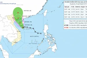
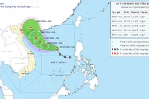
Overnight into the morning of July 4, storm No. 1 entered the Gulf of Tonkin. As of 7 a.m., the storm's center was located at about 20 degrees North latitude and 108.3 degrees East longitude, around 70 kilometers east of Bach Long Vi Special Zone in Hai Phong City and about 170 kilometers southeast of Mong Cai in Quang Ninh Province.

The storm was packing sustained winds of 62-88 kilometers per hour (force 8-9), with gusts up to force 11, and was moving northwest at 15-20 kilometers per hour.
Under the storm's influence, the Gulf of Tonkin, including the special zones of Bach Long Vi, Van Don, Co To and Cat Hai, as well as Hon Dau Island, is expected to experience winds of force 6-7, increasing to force 8-9 near the storm's center, with gusts of up to force 11. Waves are forecast to reach two to four meters, creating very rough seas that pose risks to fishing boats, cargo vessels, tourist boats and other marine traffic.
From midday to the afternoon of July 4, coastal areas of Quang Ninh, Hai Phong and Hung Yen are forecast to experience winds of force 6, strengthening to force 7-8 near the storm's center, with gusts of force 9-10. Storm surges of 0.2-0.4 meters and waves of two to three meters could cause localized flooding in river mouths, tidal flats and low-lying coastal areas.
Strong winds may damage homes, uproot trees and disrupt power, communications and transportation networks.
The weather agency also forecast heavy to very heavy rainfall across northeastern Vietnam and Thanh Hoa from July 4 through July 5. Rainfall is expected to total 100-200 mm, with 200-300 mm forecast across much of the northeast and isolated areas receiving more than 500 mm, raising the risk of flash floods, landslides and urban flooding.