As reported by the Joint Typhoon Warning Center (JTWC - USA), storm Bualoi is advancing rapidly in a West-Northwest direction at a speed of approximately 31 km per hour. It is anticipated to intensify to levels 15-16 upon entering the East Sea. The waves in proximity to the storm's center may reach heights of up to 7.3 meters.
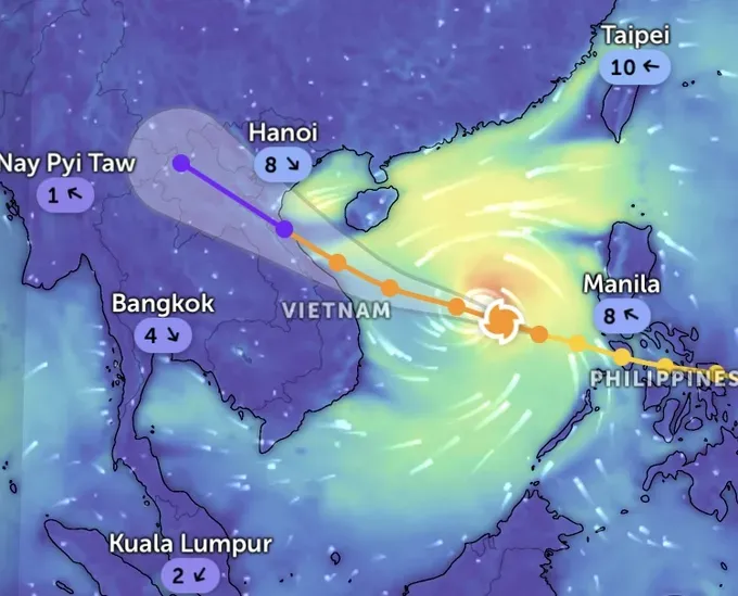
The storm is currently in a highly favorable marine and atmospheric environment, leading to forecasts of rapid strengthening. The National Center for Hydro-Meteorological Forecasting, in an update at 4:00 a.m. on September 27, placed the storm's center about 580 km East-Southeast of the Hoang Sa archipelago, with current wind speeds at level 11-12, gusting to level 15.
Crucially, the JTWC warns that as storm Bualoi enters the East Sea, it is likely to intensify dramatically, potentially reaching level 15-16. Forecasters suggest that within the next 36 hours, Bualoi's maximum wind speed could hit a devastating 185 km per hour (equivalent to level 15-16, gusting above level 17 on the Vietnam scale). Waves near the storm's center are already projected to crest as high as 7.3 meters.
What makes storm Bualoi particularly dangerous is its extreme velocity. The storm's current estimated speed of 35-40 km per hour is nearly double the average speed of a typical storm, a pace compared to inner-city motorbike traffic. This high speed gives coastal provinces minimal time for preparation and evacuation efforts.
Director Mai Van Khiem of the National Center for Hydro-Meteorological Forecasting has issued a warning regarding a rapidly advancing storm characterized by its strong intensity and extensive range of effects. This storm poses the risk of combined impacts, including severe winds, heavy rainfall, flooding, flash floods, landslides, and coastal inundation.
The storm is predicted to make landfall on the morning of September 29, with its center expected to enter the region spanning from the Central Province of Nghe An to the northern part of the Central Province of Quang Tri. As it approaches the mainland, the maritime area from Da Nang - Hue to Ha Tinh is anticipated to experience the most intense winds, reaching levels 12-13, with gusts potentially reaching level 16. Upon making landfall, the storm's intensity is expected to diminish to levels 8-9, with gusts up to level 11.
In light of the storm's circulation effects, the Northern Delta, Thanh Hoa, and Ha Tinh areas are projected to receive extremely heavy rainfall, typically ranging from 200-400mm, with some areas possibly exceeding 600mm.
Storm Bualoi is being warned as a dangerous tropical cyclone, which can cause rough seas, rising water, flash floods and landslides in many areas. Localities in the affected areas need to closely monitor the situation and proactively prepare storm prevention and response plans early.


