There are 1,500 square meters of 3 and 4-year-old durian trees on the hill behind the police station.
It is said that the green zone of the forest has been destroyed and plowed parallel with the slopes of hills to plant trees, breaking the adhesion between soil layers and causing landslides when it heavily rains.
Speaking at a working session with Deputy Prime Minister Tran Luu Quang, Chairman of the People’s Committee of Lam Dong Province Tran Van Hiep said that prolonged rains making the soil soft and loose were the reason why landslides started to happen in many places in the province, including the incident in Bao Loc Pass.
According to Chairman of the People’s Committee of Da Huoai District in Lam Dong Province Le Binh Minh, the locality has delegated the Department of Natural Resources and Environment and the Office of the People’s Committee of the district to check land handover documents to identify types of land and the landowners over the periods before releasing official information.
 |
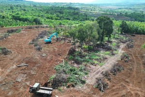
Google Earth showed that the area behind the police station which was buried in the landslide in Bao Loc Pass in Lam Dong Province was a green zone with sparse and dense vegetation in 2019. |
 |
| The zone was destroyed and leveled from the hillside to the opposite side in 2021. |
") |
| The scene of the landslide in Bao Loc Pass (Photo: SGGP) |