 |
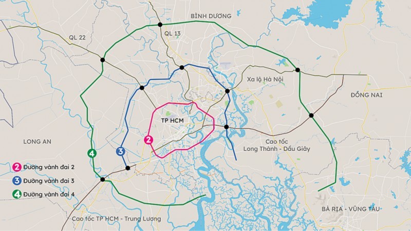
Map of Ring Road 4 |
Accordingly, the Transport Department of the city launches three plans to change the direction of the road to reduce capital and compensation. After consideration, the best project will be chosen for implementation.
Plan 1 will have a length of 17.35 kilometers, the smallest clearance area of around 154.49 hectares, total capital of VND17,791 billion (US$747 million), and the highest cost of site clearance compensation.
Plan 2 will see an adjustment with a total length of 17.29 kilometers, a clearance area of around 154.05 hectares, and a total capital of VND13,803 billion. Compensation costs for the project will be decreased
Plan 3 will have a length of 16.75 kilometers, a clearance area of around 150 hectares, a total capital of VND13,631 billion, and the smallest cost of site clearance compensation. In addition, it has convenient access to traffic, with HCMC-Long Thanh-Dau Giay and Ben Luc-Long Thanh expressways.
The construction of ring road 4 through HCMC and the provinces of Binh Duong, Dong Nai, Long An, and Ba Ria-Vung Tau is expected to be kicked off in 2024 and completed before 2028.
Under Vietnam's road development plan in 2021-2030, with a vision towards 2050 approved by the PM on September 1, 2021, the 8-lane Ring Road No.4 has a length of 199 kilometers, running from Bien Hoa-Vung Tau expressway in Phu My Town in Ba Ria-Vung Tau Province to Hiep Phuoc Port in HCMC.
The section passing through HCMC is approximately 17km long; Dong Nai province is about 45km long, Binh Duong province is about 49km long, and Long An province is about 71km long.
The Prime Minister previously asked HCMC and the provinces of Binh Duong, Dong Nai, Long An and Ba Ria-Vung Tau to implement the works of the sections running through every locality.
The Prime Minister also delegated the HCMC Transport Department to take responsibility for coordinating with the functional departments of provinces to build a pre-feasibility study report on the construction of Ring Road No.4.


