|
The Central region copes with possible landslides, erosion due to heavy rains |
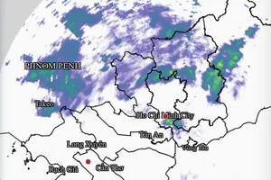
Yesterday’s prolonged heavy rain combined with reservoirs upstream of rivers discharging water caused many traffic routes and residential areas in Quang Tri and Thua Thien Hue provinces to be flooded and cut off.
In Dong Ha City of Quang Tri Province, heavy rain caused Truong Chinh, Phan Van Tri, Dang Dung, Ngo Sy Lien, Mac Dinh Chi, Thanh Tinh, Truong Chinh, Phan Dinh Phung, and Dien Bien Phu roads to be partially inundated. Thousands of houses were surrounded by water, people were run off their feet to pack up their belongings to higher places.
In particular, Truong Chinh Street leading to Phan Dinh Phung Secondary School was under one-meter deep water; as a result, the school had to let students leave school, and teachers were urged to come to the school to move tables, chairs, and school supplies up high.
The Steering Committee for Natural Disaster Prevention and Search and Rescue of Quang Tri Province said that heavy rain from the night of October 23 until the morning of October 24 caused Dong Ha City under the floodwater. In the two mountainous districts of Huong Hoa and Dakrong, 17 underground overflows were flooded by 0.5-2m while some villages and inter-commune roads in Hai Lang District were under 0.2-0.6 meter water.
Worse, prolonged downpours have flooded the National Highway 9 from Dong Ha to Lao Bao and National Highway 15D and caused traffic chaos on the highway. Currently, responsible forces have deployed guards and arranged barriers and warning signs at underground locations, landslide risk venues, and dangerous areas.
Yesterday, the Huong Dien power station upstream of Bo River discharged water downstream from 700-800 cubic meters per sec according to the order of the Steering Committee for Natural Disaster Prevention and Search and Rescue of Thua Thien Hue province to cope with heavy rains and floods. Heavy rain and Huong Dien hydropower plant water discharge caused provincial roads 4B, 6B, 8A, and 10C to be partially flooded, making residents’ traveling difficult.
Many low-lying residential areas in Phong Dien and Quang Dien districts which have not had time to drain water after heavy rain last weekend continue to be flooded and separated, making people's lives more difficult.
Meanwhile, Lieutenant Colonel Nguyen Khac Hao, Deputy Chief of Operations at Cau Treo International Border Gate Border Guard Station in Ha Tinh Province, said that National Highway 8 passes through Kham Cat District of Bolykhamxay Province and Khun Kham District of Kham Muon Province in Laos suffered landslides due to the recent floods and have been cleared.
However because the Highway 8 area is not really safe, Lao authorities still prohibit vehicles from transporting goods and passengers from Laos through the Cau Treo international border gate and vice versa. Vehicles mainly move to other routes such as Cha Lo international border gate in Quang Binh Province, Lao Bao international border gate in Quang Tri Province, and Nam Can international border gate in Nghe An Province.
Previously, Sai Gon Giai Phong Newspaper reported that due to the impact of prolonged floods in early August 2023, cascading soil, rocks and trees ground traffic in the National Highway 8 in Laos which is dozens of kilometers from the Cau Treo international border gate in Ha Tinh Province’s Huong Son district to a halt. Moreover, many vehicles were trapped and buried in serious landslides.
To cope with the risk of serious erosion on the banks of the Ngan Pho River, Chairman of the People's Committee of Huong Son District Tran Binh Than also submitted a proposal to the Provincial People's Committee and competent agencies to approve the policy of adjusting the feasibility study of the Ngan Pho riverbank landslide treatment project, with a total cost of nearly VND120 billion (US$4,852,014) taken from the central and local budgets.
The project will build 5 embankments with a total length of more than 3.2km communes of Son Long, Tan My Ha, An Hoa Thinh, Son Trung, and Quang Diem.
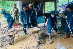
Elsewhere in Binh Dinh Province, Chairman of the provincial People's Committee Pham Anh Tuan has just directed the Department of Agriculture and Rural Development and localities to comprehensively review riverbank erosion and mountain landslides and people in landslide-prone areas to prepare a scenario to respond to the natural disasters and relocation plan when heavy rains and floods battered the province.
He especially emphasized the plan to prevent landslides in the Cam Mountain area in Cat Thanh Commune in Phu Cat District and the Hon Cha Mountain in Quy Nhon City’s Tran Quang Dieu Ward. The province will plant trees in protective forests in mountainous landslides. During the 2021 rainy season, Cam Mountain suddenly collapsed into a stream hundreds of meters long, threatening the property and lives of 117 households at the foot of the mountain.
The local authorities determined that the Hon Cha Mountain is at risk of landslides with an area of 9,714 square meters. Previously, the Provincial People's Committee allowed Xuan Nguyen Company to lease land in the mountain for expanding its granite processing factory but the government later revoked the license due to the consequences of the enterprise's salvage exploitation of stone. However, this mountain is still being illegally excavated.


)