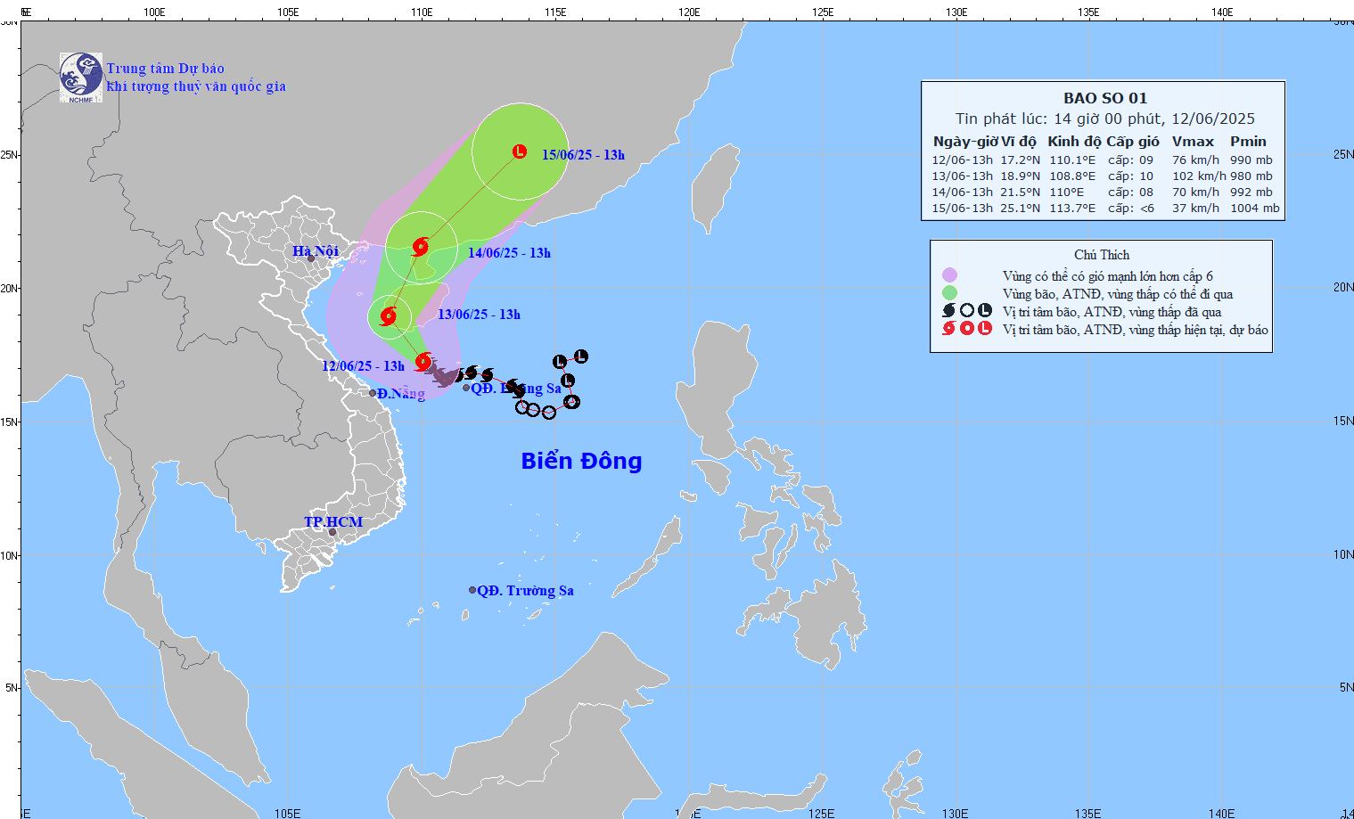
According to Mr. Phung Tien Dung, Head of the Hydrological Forecasting Department at the National Center for Hydro-Meteorological Forecasting, the storm's center was positioned west of the Hoang Sa (Paracel) Islands yesterday, packing wind speeds of level 8–9. In the next 24 hours, it is expected to move northwest at roughly 10 kilometers per hour, intensify, and then veer north toward China’s Guangdong and Guangxi provinces before weakening.
Wutip is forecast to continue producing strong winds and heavy rains over the northern East Sea and the Gulf of Tonkin, while also driving intense downpours across Central Vietnam.
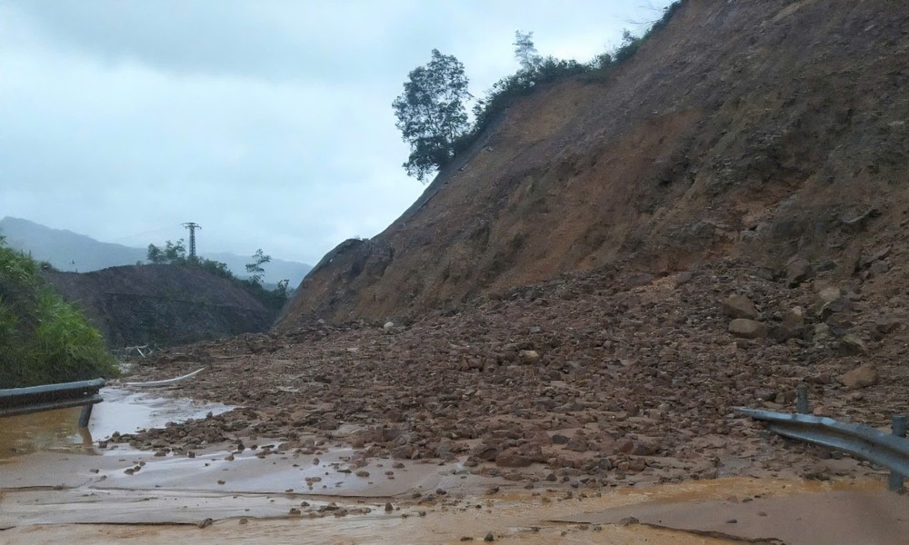
Mr. Phung Tien Dung noted that persistent, large-scale rainfall has already heightened the risk of flash floods and landslides in the region. Water levels in many rivers have rapidly surged, in some places exceeding danger thresholds.
By midday June 12, heavy rain had spread across provinces from Quang Binh to Quang Ngai and into Kon Tum, with rainfall ranging between 150mm and 250mm. Several areas recorded much higher totals, including 574mm in Thuong Lo, 378mm in Giang Hai, 421mm in Suoi Luong (Da Nang), and over 350mm in Dai Hiep and Dai Son (Quang Nam). In Quang Binh and Quang Tri, multiple monitoring stations registered over 200mm.
The deluge caused water levels on several rivers to exceed warning level 1. In Quang Binh, the Kien Giang River rose to 8.59m—0.59m above the alert threshold. In Hue, the Thuong Nhat Station on the Ta Trach River recorded 60.34m—1.34m above the alarm level. In Quang Nam, the Vu Gia River at Ai Nghia reached 7.23m, while the Cai River at Thanh My surged to 16.27m—both exceeding warning level 1 by more than 0.7m.

Flooding and damage have been reported across Quang Binh, Quang Tri, Da Nang, and Quang Nam. In Dai Loc District (Quang Nam), 300 homes were inundated. At sea, two Quang Binh fishing boats (QB-93451-TS and QB-92756-TS) sank while operating offshore, and another vessel docked in Da Nang went down. All eight crew members were safely rescued by nearby boats.
Floodwaters also damaged about 22,500 hectares of crops and farmland: Hue accounted for 12,758ha, Quang Tri 8,246ha, and Da Nang 1,497ha. Da Nang also reported damage to 33ha of aquaculture farms.
In terms of transportation, Quang Tri reported seven submerged spillways in Dak Rong District. In Hue, landslides occurred along National Route 14C, the La Son–Tuy Loan Expressway, and the Ho Chi Minh Highway section through A Luoi District. In Da Nang, multiple urban roads were briefly inundated (with water now receded), and two rural roads experienced landslides. Quang Nam saw localized flooding along provincial roads 603B, 609, and 615B.
No casualties have been reported as of midday June 12, according to the Department of Dike Management and Natural Disaster Prevention and Control.
In Hue, rainfall has reached levels rarely seen during the summer months, with total precipitation exceeding 300mm in a compressed timeframe. Flooding and landslides were reported in various parts of the city. One major landslide blocked access to the La Son–Tuy Loan Expressway through Huong Phu Commune (Phu Loc District), prompting authorities to close the route temporarily until weather conditions improve enough to allow for debris clearance and repairs.

In response to the severe weather, the Hue City Steering Committee for Natural Disaster Prevention and Search and Rescue has instructed local authorities to remain on high alert, follow the "four-on-the-spot" disaster response protocol, and prepare for emergency evacuations and rescue operations if necessary. All fishing vessels have been ordered to dock and shelter in safe zones.
Meanwhile, the committee has also initiated a controlled release of water from the Huong Dien Hydropower Reservoir on the upper Bo River to protect the dam and downstream communities. As of 11 a.m. on June 12, the reservoir’s water level stood at +57.09m, with an inflow of 2,899 cubic meters per second and an outflow of 104 cubic meters per second. The discharge volume is being gradually increased to between 400 and 800 cubic meters per second, starting from 3:10 p.m. the same day, with adjustments made in response to real-time conditions.