")
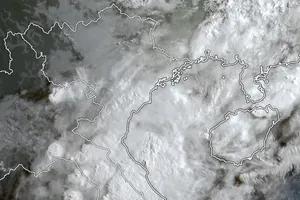
The system was packing maximum sustained winds of 62-74 km/h with gusts reaching 110 km/h, moving in a northwestward direction at approximately 20 km/h.
Over the next 72-120 hours, the typhoon is projected to move predominantly westward at a speed of 10 km/h, with the potential for intensification.
It is anticipated that Yagi will enter the East Sea by late afternoon or evening today. From midday onwards, the northeastern waters of the northern East Sea will experience a gradual increase in wind speeds to level 6 (39-50 kilometers per hour), with gusts exceeding level 11 (102-117 kilometers per hour) near the typhoon's center, resulting in rough seas.
Between September 4-6, Yagi is forecast to intensify into a very strong typhoon over the northeastern East Sea, with maximum sustained winds potentially reaching 165-185 km/h and gusts exceeding 200 km/h near the center.
Within the next 24 hours, the eastern waters of the northern East Sea are expected to experience significant wave heights of 2-4 meters, increasing to 3-5 meters near the typhoon's eye and potentially reaching 5-7 meters subsequently, resulting in extremely dangerous sea states, posing a severe threat to maritime operations.
Tonight, the Central Highlands and Southern regions of Vietnam will encounter moderate to heavy rain and thunderstorms, with localized torrential downpours producing accumulated precipitation of 20-40 mm, and possibly exceeding 100 mm in certain areas.
Scattered showers and thunderstorms are predicted for the Central Coastal region, with localized heavy rainfall of 15-30 mm and potentially exceeding 70 mm, particularly during the late afternoon and night, accompanied by tornadoes, lightning, and strong wind gusts.
The northern, central, and southern parts of the East Sea (including the Paracel and Spratly Islands), as well as the waters from Quang Tri to Ca Mau, Ca Mau to Kien Giang, and the Gulf of Thailand, are forecast to experience scattered showers and thunderstorms. Tornadoes and strong wind gusts of force 7-8 are possible within these thunderstorms, and wave heights may exceed 2 meters at times.

Hanoi is expecting cloudy skies with scattered showers in the morning, then sunny in the afternoon. Light winds. Temperatures will range from 26-28°C low to 33-35°C high.
In the North of Vietnam, it is cloudy with sunny spells, and possibly hot in some areas. Isolated showers and thunderstorms are expected in the late afternoon and evening. Light winds are expected. Tornadoes, lightning, and strong gusts are possible during thunderstorms. Temperatures will range from 24-27°C low to 32-35°C high.
From Thanh Hoa Province to Binh Thuan Province, it is forecast to be cloudy with scattered showers and thunderstorms throughout the day. Isolated heavy rain is expected in the late afternoon and evening. Light winds are expected. Tornadoes, lightning, and strong gusts are possible during thunderstorms. Temperatures will range from 24-27°C low to 31-34°C high.
The Southern region is predicted to experience cloudy skies and scattered showers and thunderstorms throughout the day. Moderate to heavy rain and thunderstorms are expected in the afternoon and evening, with localized torrential downpours. Southwest winds are at force 2-3. Tornadoes, lightning, and strong gusts are possible during thunderstorms. Temperatures will range from 23-26°C low to 29-32°C high.