")
The information was updated from the Joint Typhoon Warning Center (the US) at 5 p.m. on October 19 (Vietnam time).
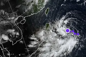
At the same time, the National Center for Hydro-Meteorological Forecasting also said that Fengshen has entered the East Sea, becoming the 12th storm affecting Vietnam this year. The typhoon is forecast to bring strong winds, high waves, and hazardous weather in the coming days.
At 3:00 p.m. on October 19, the center of typhoon Fengshen was located at approximately 15.2 degrees North latitude and 119.7 degrees East longitude. The maximum sustained winds near the eye of the storm reached level 9, moving northwest at 20–25 km/h.
By the afternoon of October 20, the typhoon’s center is forecast to be in the northern part of the East Sea, about 380 km east-northeast of the Hoang Sa (Paracel) Archipelago, with sustained winds of level 10 (89–102 km/h), gusting to 12 (118–133 km/h).
On October 21, the typhoon will move westward at a speed of 10–15 km/h, located about 200 km north of Hoang Sa, with winds reaching level 11 (103–117 km/h) and gusts up to level 13. It is forecast to shift southwestward, about 220 km northeast of Da Nang in the afternoon of October 22, weakening to level 9 with gusts up to level 11.
After that, Fengshen will continue moving southwestward at a speed of around 10 km/h and gradually weaken.
Although the typhoon may weaken as it moves inland over Central Vietnam, weather conditions over the East Sea and the central coastal waters remain extremely dangerous. The National Center for Hydro-Meteorological Forecasting has issued a level-3 natural disaster risk warning for the northern part of the East Sea (including the Hoang Sa Archipelago) and the waters from Hue to Quang Ngai.
As the typhoon interacts with a cold air mass and easterly winds aloft, inland areas of Central Vietnam from Nghe An to Quang Ngai should be on alert for moderate to heavy rainfall, with very heavy rain in some places, posing risks of flash floods and landslides in mountainous areas and flooding in low-lying regions.


)


