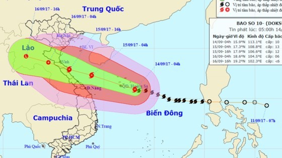
Within next 24 hours, the storm will move the west- northwestward at 20 kilometers an hour.
By 7am tomorrow, its eye will be at 17.4 degrees north latitude and 107.8 degrees east longitude in the central territorial waters from Nghe An to Quang Tri provinces. The most powerful wind near the center will gust 115- 150 kilometers an hours.
Because of its influence, the western territorial waters of the north- East Sea including the Paracel Island will see wind speed of level 10-11, even up to level 12- 15 and sea rough.
In next 24- 36 hours, typhoon Doksuri will continue moving the west- northwestward at 20 kilometers an hour.
By afternoon tomorrow, this year’s the tenth storm hitting the East Sea is forecast to enter the mainland of the central provinces from Nghe An to Quang Tri.
By 7pm, its next position will be at 18.1 degrees north latitude and 105.6 degrees east longitude between the Vietnam- Laos border line with the powerful wind of level 9- 12.
On September 16, the tropical storm will enter the mainland before it is predicted to be weakened into the depression zone in Upper Laos.
The National Hydrology Meteorology Forecast Center also warned powerful wind and big wave on sea in the central provinces.
By evening of September 14, the coastal territorial waters from Quang Tri to Quang Ngai including Con Co, Cu Lao Cham and Ly Son islands will suffer strong wind of level 6-10 and sea rough.
The waters from Thanh Hoa to Quang Binh including Hon Ngu Island, the Gulf of Tonkin will experience wind speed of level 6- 9, sea rough and big waves of 2 meters.
By the early tomorrow morning, the coastal provinces of Nghe An. Ha Tinh, Quang Binh, Quang Tri, Quang Ninh, Hai Phong, Thu Thien- Hue and Da Nang will see big wave and strong wind.
Heavy rains are warned to experience in the provinces from Quang Ngai to Nghe An with its rainfall of 100- 400 mm.


)
