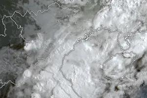
Speaking at the conference, Director of the National Center for Hydrology Meteorology Forecasting Mai Van Khiem informed that international forecasting agencies constantly changed their predictions about the paths and intensity of the tropical depression, which is expected to travel to the Northern region or may be expected to make landfall in the Central region of Vietnam. However, Vietnam’s hydro-meteorology forecasting agency said that the tropical low-pressure system will be likely to turn into a storm in the next several hours. The system will move northwest between the North-Central and Mid-Central regions as it approaches closely the mainland.

From October 9 to October 12, the tropical typhoon may be expected to interact with a cold spell, triggering rainy weather across the North- Central and Northern regions on the large scale.
In October, the Central region is warning for a higher rainfall volume from 15 percent to 20 percent compared to previous years as the La Nina phenomenon is coming back along with this year’s cold waves which tend to come sooner than the previous years, likely affecting the Central region’s weather condition.

In the next 36-48 hours, the system is able to slowly move north-northwest at a speed of five kilometers an hour. By 7 a.m. on October 9, the tropical depression will intensify into a storm in the southern territorial waters of Hainan Island (China).
All vessels working in the dangerous areas will likely brace for blustery winds, rough sea and big waves.

The bans on bathing have been issued at beaches across the coastal city of Da Nang and Thua Thien- Hue Province.
Provinces from Thanh Hoa to Quang Ngai are ready to evacuate 71,559 households with 290,671 people living in coastal areas. Amid the current Covid-19 pandemic situation, the local authorities are reviewing the number of coronavirus infections and other cases related to Covid-19 to proactively prepare for evacuation and isolation.


