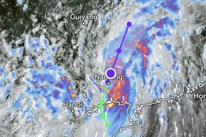
After that, the potential storm will move west-northwestward and approach Vietnam’s Central coasts.
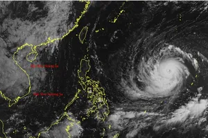
As of September 18 morning, Head of the weather forecast department at the National Center for Hydrological and Meteorological Forecasting Nguyen Van Huong provided information and a path map of the tropical low-pressure system in the East Sea which is forecast to strengthen into a storm.
The Border Guard of Quang Binh Province has urged measures to respond to the tropical depression, added Mr. Nguyen Van Huong.
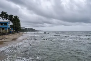
Extreme rains pounded in the North Central and Central coastal regions from last night to this early morning.
It is anticipated that these regions will experience intense rainfall of 300 mm above from September 18 to September 20.
The provinces and cities of Ha Tinh, Quang Binh, Quang Tri, Da Nang and Quang Nam are warned of potential flash floods and landslides.
The Department of Dyke Management and Disaster Prevention announced that the Ministry of Agriculture and Rural Development would organize a meeting to instruct measures against the potential storm on September 18 morning.
Deputy Minister Nguyen Hoang Hiep will preside over the working session.
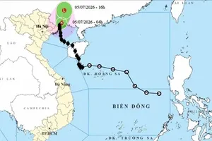
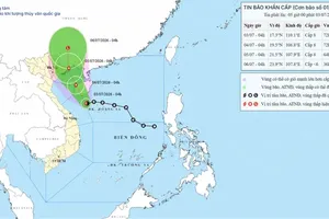
According to the National Center for Hydrological and Meteorological Forecasting, at around 7 a.m. on September 19, the tropical depression was located at approximately 16.7 degrees North latitude and 113.5 degrees East longitude, about 180 kilometers east of the Paracel Islands. The strongest winds near its center reached level 7 (50-61 kilometers per hour), shock level 9.
The tropical depression is moving westward at an hourly speed of about 15 kilometers.
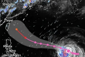
By 10 a.m. on September 19, the tropical depression is expected to move west-southwest at a speed of 20 kilometers per hour and intensify into a storm.
The center of the storm will be located at approximately 16.7 degrees North latitude and 108.4 degrees East longitude, about 110 kilometers east southeast of Quang Tri coastal province.
The western waters of the North East Sea including the Paracel Islands and the Central coastal areas from Ha Tinh to Quang Ngai including Ly Son Island, Cu Lao Cham and Con Co Island will be affected by the storm.
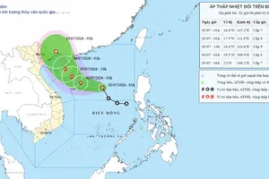
By 10 a.m. in next day, the storm will shift west-northwest at an hourly speed of 15 kilometers, make landfall and gradually downgrade over the Vietnam-Laos border.
The western waters of the North East Sea including the Paracel Islands and the Central coastal areas from Ha Tinh to Quang Ngai including Ly Son Island, Cu Lao Cham, Con Co and Hon Ngu Island will continue to brace for impacts of the storm with strong gale of 89-102 kilometers per hour, huge waves of two to five meters and rough sea.
Due to the influence of the potential storm, blustery winds and thundery downpours are expected to pound the Central coasts and mainland area from Ha Tinh to Quang Ngai from September 18 to September 20.
The Border Guard of Quang Binh Province urges measures to respond to the tropical depression.

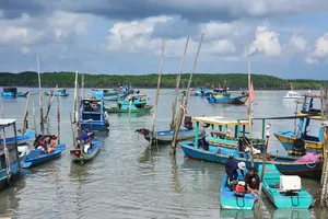
Last night, maritime radio stations issued hundreds of notifications urging vessels operating in hazardous waters to seek safe shelters.

The local authorities have tracked and regularly updated the itineraries for vessels at sea. According to vessel monitoring systems, Quang Binh Province has 7,313 vessels with 18,979 workers operating at sea.
As of 10 a.m. on September 18, 7,262 vessels were anchored at ports and 51 vessels are currently operating at sea. Currently, eight vessels with 40 workers are anchored off Sa Ky Port in Quang Ngai Province.