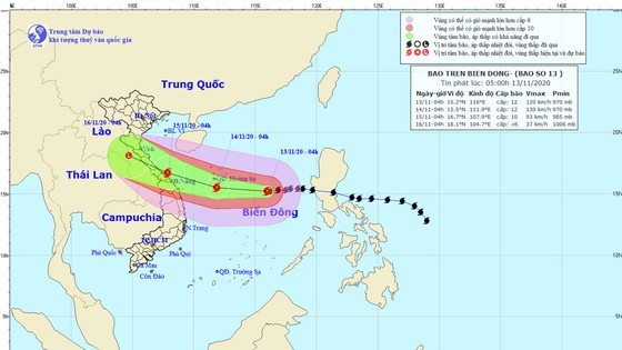
According to the National Center for Hydro-meteorology Forecasting, the storm currently emerges at around 450 kilometers far from east southeast of the Paracel Islands with winds of level 15. In the next 24- 48 hours, the typhoon will first sweep through territorial waters from Quang Binh to Quang Nam with its strongest winds of level 13 before entering mainland provinces from Ha Tinh to Thua Thien- Hue and gradually downgrading into a tropical depression and low-pressure zone.
At around 4AM on Tuesday, the tropical depression will be at central Laos.
The continental high pressure together with an impact of the typhoon will trigger gale-force winds, big waves and rough sea in the territorial waters from Quang Tri to Ninh Thuan, from Quang Tri to Quang Ngai, the northern territorial water of the East Sea including the Paracel Islands and the middle of the East Sea as of the early tomorrow morning.







)


